
At 490 masl Tinsdtinden in Lofoten may be considered just a small hill, but it makes an incredibly awarding hike topped off with astonishing panoramic views to lake Agvatnet and villages: A, Sorvagen and Moskenes. Hike to Tindstinden is short and relatively straight forward, however the final approach to the summit may be perceived as airy by some.
Continue reading to find out how to hike to Tindstinden, what to expect along the way and how we were positively surprised by the experience!
Hike to Tindstinden Lofoten

- Height: 490 masl
- Total time: 3 hours
- Total distance: 5 km
- Parking: car park in Sorvagen (directions), charge applies (50 NOK per day, paid cash – summer 2019)
- Level of difficulty: 3/5 – medium difficulty hill walk, with a short very steep climb and a mildly exposed ridge traverse. Initial section involves use of a couple of ropes
- Tindstinden weather: weather forecast for Tindstinden
How to get to Tindstinden trail head
Trail to Tindstinden starts at the dedicated visitors car park in Sorvagen, by the shores of lake Sorvagvatnet (directions). It’s worth to keep in mind that, despite the car park being recently extended, it fills up very quickly, as it’s a starting point for several hiking trails: circular trail around Sorvagvatnet, path to a waterfall on Studalselva, footpath to Moskenes, trail to Munkebu hut and Munken, Tindstinden, and Hermannsdalstinden. Therefore we recommend hiking to Tindstinden either in the morning or in the afternoon – but please, ensure to have sufficient time to descent before nightfall!

Hiking trail to Tindstinden
Take the well made trail leaving the visitors car park in Sorvagen, signposted to the waterfall and Munkebu hut. During the first couple of hundred metres you’ll pass lake Sorvagenvatnet (to your right) and soon will come to a large smooth boulder. Yes, that’s the way further! Once at the top of the rock, you’ll finally see the waterfall on river Studalselva. To be honest, the waterfall itself is worth a visit!

Still at the top of the large boulder, look for worn surface where many walkers made their way to the little footbridge over the stream (a bit to your right). Past the footbridge, you’re on a main, well defined trail which Tindstinden shares with Munkebu hut for a couple of hundred metres.
Very soon you’ll come to shores of another lake, Studalsvatnet, and see a large notice board ‘drinking water, no bathing’. This is where you should leave the main trail and turn left, follow one of several smaller paths running along the lake.
Please ensure to stay close to the lake, as very soon you’ll have to cross a bigger stream and there is a bridge, which makes the crossing problem-less.
Next several hundred metres are a constant up-and-down, jumping between rock ribs and small wet areas. Luckily, all spots where one could have trouble progressing further, were secured with ropes, which makes things much easier.
At that point, already, views to nearby rocky mountains, and over the lake are fantastic. A bit to the left is Tindstinden; OK it may look a bit imposing at the beginning of the hike, but as you come nearer, it seems to be melting into a much smaller mountain that previously thought.
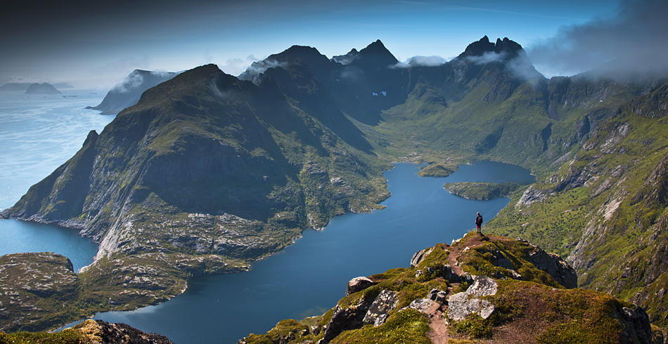
Follow a narrow and rocky path along slopes of Tindstinden’s neighbour; keep to the right at the fork and continue up to the saddle on a ridge, directly in front of you. Final steps before reaching the ridge will increase your heart rate, but as soon as you set your feet on level ground, you’ll forget all about it. The most spectacular scenery of hike to Tindstinden Lofoten is now before your eyes. Look down to the long lake Agvatnet, walled by jagged ridges and rugged mountains of the westernmost part of Lofoten.
Carefully continue along the ridge, towards Tindstinden summit. Some may find it airy or exposed, but only slightly, and take our word for it – it’s worth the effort! The summit is already within 10-15 minutes walk.
Top of Tindstinden doesn’t have the ‘exposed’ feeling, nor is difficult to reach; the summit area is relatively spacious. If, somehow, the view gets spoilt by incoming clouds – give it some time, the clouds are likely to be blown away!
Tindstinden summit views awed us; apart from the lakes and ridges, we could finally see village A directly below us!
Once we were satisfied with the incredible scenery around, we retraced our steps to the car park in Sorvagen.

Tindstinden – a surprisingly nice short hike in Lofoten
We were very keen to conquer Tindstinden as it was very often refereed to as ‘an amazing viewpoint over village A’. Usually, when thinking about Lofoten, comes to mind a view of rugged mountains, blue lakes and some small villages, dramatically composed in the narrow space between water and the mountains. We expected to witness a similar view, when hiking to Tindstinden.
However, we thought it was only going to be a short hike to a viewpoint, and couple of photographs later we will quickly descent and get on with our trip.

But as soon as we left the main path near lake Stuvdalsvatnet, we felt that the hike may actually be more interesting and exciting than we anticipated. Negotiating the ‘ups and downs’, lifting ourselves on the rope added to the experience.
Once we reached the summit ridge, we were awed! Yep, it was a bit exposed in places, but we were so focused on spectacular view of lake Agvatnet, that we didn’t even realise how quickly we progressed towards the summit. In fact, we really enjoyed the traverse with dramatic view to the westernmost part of Lofotodden National Park

When we arrived to the summit, we were amazed. Not only by the panoramic views over Lofoten and nearby islands (including Værøy!), but also by the hiking experience. We felt that getting to the top of Tindstinden was much more exciting hike than we imagined – a bit of a challenge, a bit of an excitement, all topped off with incredible view! We didn’t expect to have such fun while hiking to Tindstinden, and we think that naming it ‘just a viewpoint over village A’ doesn’t really do the justice to this little mountain.
We spent about one hour at the top, just couldn’t get enough of the scenery around us, but also enjoyed the fact that most of the time we had the summit to ourselves!
OK, let’s have a closer look at some of these vistas; we hope they’ll inspire you to include in your Lofoten trip itinerary.


Tindstinden hiking map

What we loved about hiking to Tindstinden Lofoten
I think we both tremendously enjoyed being so positively surprised by the hike! The excitement of traversing the narrow summit ridge, spectacular panoramic views, and also the fact that looking in all directions we were already able to name peaks, villages and islands stretching far, towards the horizon. Tindstinden was our last hike in the western part of Moskenesoya (and Lofoten) and I think it was a perfect way of saying ‘good-bye’ to this area. Would we hike to Tindstinden again? Undoubtedly ‘a big YES’!
Wild camping near Tindstinden and the nearest campsite
By general rule, in Norway, wild camping is only allowed 150 metres from nearby dwellings, however on many occasions we found notices put by the locals that they do not wish campers to stay overnight on their land… and we respected it.
There is a very good spot for overnight stay with a camper van or a motorhome near Sorvagen village. It is a large free car park at the very end of the road, in village Å. There is a toilet available and for such large car park it is relatively quiet. Located at the western end of Moskenesoya island it’s only 3 km from Sorvagen!
Finding a decent spot to wild camp with a tent is a bit trickier as the lower ground in Lofoten is generally very wet or rocky. Grounds near car park in Å are not suitable and camping is forbidden, the same applies to Sorvagen area, however we noticed many campers pitching their tents around lake Sorvagvatnet. Please, keep in mind that lake Stuvdalsvatnet is a source of drinking water, and behave respectfully, don’t pollute it and don’t camp nearby.
There are two campsites near Moskenes/Sorvagen although in my opinion they’re overpriced. Moskenes Camping located near ferry harbour has good and clean facilities and a pub/bar, but virtually no WiFi. A night stay with a small camper set us back 320 NOK (340 NOK with electricity) which we thought was a bit of a rip off. There is also a campsite in village Å, but we’re unable to comment on its facilities and price.
LOOKING FOR OTHER AMAZING HIKES AND BEACH WALKS IN LOFOTEN?
If you’re looking for other hiking ideas on Lofoten archipelago, check out these amazing hill and beach walks! All include detailed route descriptions and maps:
VEGGEN – a short, but steep hike to an amazing viewpoint over Uttakleiv and Haukland beach. You may be lucky to spot the pair of eagles nesting in Veggen’s crags!
KVALVIKA BEACH AND RYTEN – why not combine conquering Ryten with a visit to Lofoten’s gem beach – Kvalvika? A great, rewarding hike in Lofoten’s wild mountains.
ROREN AND YTTERSAND BEACH – short and easy hike to Roren, a viewpoint over calm waters of Flakstadoya and Yttersand Beach. Why not enjoy eagle-eye view first, and then descend to the picturesque sandy beach?
FLOYA AND DJEVELPORTEN – a great, challenging hike to Djevelporten boulder and stunning viewpoint along Floya ridge, over the town and islands of Svolvaer.
MATMORA – a fine ridge walk off the main Lofoten route, at the top of Austvagoya island. Enjoy stunning views and few fellow hikers
*Level of difficulty explained: 1– easy walk, mostly flat 2– easy hillwalk, good path 3-moderate, possible some steep sections 4-long hillwalk, possibly some scrambling involved, possibly pathless 5-difficult, possibly pathless, long, requires technical skills
NORWEGIAN DIFFICULTY LEVEL EXPLAINED: GREEN – easy , BLUE -moderate, RED – demanding, BLACK -expert
