
Matmora is famed for being one of the most scenic mountains in eastern Lofoten. You won’t, however, meet mad crowds while conquering it, as the mountain is located a bit off the ‘main Lofoten way’, on the northern tip of Austvagoya island. The trail leads along a rugged ridge, with spectacular views in all directions that will leave you speechless. Route is not difficult and only mildly exposed; in fact the level of exposure totally depends on your choice of path along the jagged ridge – you can either follow its edge (and that definitely is exposed) or can take a track running a bit lower, whichever feels more comfortable.
If you enjoy the great outdoors and are looking for a hike in some of the most spectacular Lofoten scenery, Matmora is perfect for you!
Hiking Matmora in Lofoten fact sheet

- Height: Matmora 787 masl
- Total time: 6 hours
- Total distance: 13 km
- Total ascent/elevation gain: 844 metres
- Parking: dedicated car park just outside Delp, Austvagoya (directions)
- Level of difficulty: 3/5 – moderate, initial ascent steep and muddy (Norwegian standard BLUE – moderate)
- Matmora weather: weather forecast for Maritsdaltinden
How to get to Matmora trailhead
Trail to Matmora begins at the back of dedicated car park and is very easy to find.
Coming from western Lofoten, follow road number E10 and turn left into road Fv888 just before Vestpollen. Continue along Fv888 for approximately 20 km, passing amazing green islands of Laukvikoyene nature reserve on your left. Just before reaching Delp, you’ll see wooden signpost ‘Matmora’ (on your right) – that’s the dedicated car park.
Coming from eastern Lofoten follow road number E10 and sharply turn right into road Fv82 just past the bridge (direction to Fiskebol). Follow the road for approximately 1 km, then take sharp left just before Fiskebol ferry harbour, into road no Fv888 and continue for another 27 km. The road will soon take you along the fjord, with views to dramatic rugged mountains towering high over water. Pass Grunnfor (modern lookout point dedicated for cyclists) and soon you’ll be facing a shallow bay walled by green mountains. The road, surprisingly, crosses the bay via two short causeways, with a tiny island in between.

Directly past the causeway is Delp; carefully drive past the tiny village until you see large rocks on your right, the dedicated Matmora car park is some 50 metres further, to your left. Drive slowly as coming from this side ‘Matmora’ signpost is obscured by trees (you’ll probably see it just a split second too late).
Keep in mind that the car park is divided into two parts – the first part tends to be wet and muddy, however don’t let it discourage you as the further part of the car park is much drier, with some grass. Check out for available parking spaces in both parts. Alternatively, if the car park is full, try nearby parking bay (approximately 50 metres west).

Evening and night hiking in Lofoten
It was already late afternoon when we finally headed to Matmora, but visiting Lofoten in summer has one great advantage – it doesn’t really get dark! The sun doesn’t set for about 2 months and without a quick look at the watch, one would struggle to distinguish day and night, not to mention guessing what time it is! Hence during our latest visit in early July, we weren’t limited by nightfall, in fact hiking in late afternoon or evening meant less fellow walkers on trails and more free space on dedicated car parks which otherwise are totally full for most of the day. It also meant enjoying the surrounding scenery in soft, warm light (weather permitting), perfect for photography enthusiasts!

Planning a visit to your dream destination can be daunting, but don’t worry! If you’re coming to Lofoten and would like to be fully prepared, why not let us help you?! Check out our ready made 7 days Lofoten Itinerary for hiking, places to visit and must-see ideas!
For essential info on preparing yourself to visiting Lofoten, as well as handy tips for your travel in this remote archipelago, read our article 13 Things You Need To Know Before Visiting Lofoten. Don’t let weather, traffic and nature surprise you! Plan your visit to Lofoten smart!
The trail to Matmora Lofoten
We have to admit, we were already awed by sheer beauty of the area even before reaching Matmora trailhead! We were lucky to visit the area on a calm, sunny day – sight of mountains mirrored in fjord was astonishing and we stopped along the road a couple of times just to take in the view.
Matmora trail starts near the dedicated car park entrance, so we headed back to the ‘muddy’ part and took the only possible path – towards wooden gate. The path was only partially marked with red dots, however was very easy to follow throughout the route. There aren’t any other trails nor paths in the area, all tracks and ‘sheep-paths’ you’ll come across will lead to Matmora.

Initial section of Matmora trail will leave you breathless and dirty! It’s a steep, 1 hour climb over muddy path, with rough rocks and boulders to cross over… so typical for Lofoten! Actually, having hit the trail, one thing that instantly came to my mind – muddy & swampy ascents were the only aspect of hiking in Lofoten I didn’t miss… but hey-ho, I’m a sucker for a good summit view!
After approximately 1 hour, with great relief, we reached a large, flat-ish plateau. Phew, the most difficult and tiring section of the hike was past us!
There are several paths cutting thru the plateau, some run nearer the left (east) edge, some in the middle, and one along its western edge. We advise to stick to the ‘most left’ path – following the east edge of the plateau and checking out all the viewpoints along the way. In fairness, visiting all the vistas and viewpoints (rather than taking the shortest route along western edge) will add another 1 km to your route, but it’s definitely worth the effort! You can take the shortest path on you return.

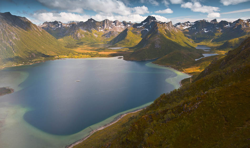
Having arrived to the higher, open ground we were finally able to have an overlook of the area, which we drove thru only a couple of hours earlier. Looking down, we saw the causeways, islets and emerald waters of bay we loved so much while driving to Matmora trailhead. Further, we noticed dozen of lakes of various sizes and colours, all that finished off with green slopes of nearby mountains, turning rocky and grey as we looked higher, countless patches of snow still remaining, despite summertime…

In spite of late hour we still met couple of walkers on the trail, heading in the same direction. They progressed faster as they skipped some further viewpoints along the plateau (we checked them all!) and with some distance between us, we didn’t disturb each other.

So, let’s quickly sum up – first section of Matmora trail is a steep, muddy path; second section is large grassy plateau. The third, and most exciting section is ‘the ridge’.
Satisfied with sights from plateau, we turned our eyes to the next part of Matmora hike – the ridge.
Far end of the plateau steadily rises and turns into a wide ridge. We struggled to keep to one path on the way up; there were several small ‘sheep-paths’ leading up and as soon as we picked one, it disappeared. It doesn’t really matter which path you follow, just continue up. As the ridge forms, a well defined path suddenly pops out and stays clear till the very Matmora summit.

Just as the broad ridge gently descents to a small saddle, you’ll get a closer look at ‘the teeth’ – sharp pinnacles, directly in front of you. If you’re feeling adventurous, follow a faint path which runs at the upper edge, very near the sharp tops of the three pinnacles. Do you dare to look down, at the abyss below? With good head for heights, you’ll be able to admire nearby valleys and lakes from new perspective, just be extremely careful.

Alternatively, if you’re not after any additional thrills, you can take a well defined path running a bit lower along the ridge. By taking it, you will avoid any exposure and will not come close to the dramatic ridge edge.

The ‘pinnacle section’ is rather short, and before we knew it, we were on a broad ridge again, heading directly to Matmora’s summit. This last part of hike is much easier than we first thought, Matmora seen from the plateau seems hard to conquer. Indeed, it is a bit rocky, so we had to be careful not to step on loose rocks, but that’s about all difficulty we came across.
A bit to Ela’s disappointment, we avoided all remaining patches of snow and all too soon we reached the top!

Matmora summit views
We could probably write a very long description of Matmora’s summit views, the way it made us feel to reach such spectacular viewpoint etc, but we will keep it short and sweet. We’re sharing the video below so you can almost feel like you’re there with us!
Matmora’s large summit cairn appeared suddenly and when we approached it, we realised that it’s a really massive one! As the weather held and the sun was shining almost continuously for hours and hours, with pleasure we picked a spot with the nicest view to have a rest. Actually, Ela picked a spot to sit and when Bea asked why there (and not facing the sun), Ela replied ‘because this one has better views!’, to which Bea laughed heartily, looked at the astonishing scenery in all directions and only commented ‘omg, girl, you’re spoiled rotten for choice!’
Despite being a bit windy, we spent almost one hour at the summit. After all, why should we hurry back? We had all the time in the world, knowing that the sun will be shining for next many hours… in fact the next sunset was to be in about two weeks time!
So what about sharing some of these amazing summit views with you now?


Return from Matmora to car park
Believe us, it was a tough decision to finally leave Matmora behind and walk back to the car park. We simply loved the views so much that couldn’t force ourselves to eventually get up and go!
When we finally did, we opted for the easy route – we retraced our steps along the lower path under the ‘teeth’, then instead of taking the by-pass path, we headed straight for the broad, gentle ridge, which was much easier and pleasant! Also, coming back we skipped the viewpoints along the plateau and headed directly, the shortest way to its end. Still, the steep, muddy path awaited us, but surprisingly, after the whole day of sunshine some of the muddiest sections dried a bit and we managed to descent without traumas.


Wild camping near Matmora and nearest campsites
Wild camping is allowed and widely accepted in Norway. By law, everyone is allowed to stay overnight at any spot at least 150 metres from nearby buildings. As much as it sounds great, in reality finding a wild camping spot in Lofoten can be very tricky as they’re relatively highly populated. On many occasions suitable camping spots are blocked or marked as private grounds with camping forbidden.
Near Matmora we can recommend two good wild camping spots suitable for camper vans – Matmora’s dedicated car park (after the hike we stayed there overnight without trouble), or couple of kilometres further, along a quiet track past cemetery (directions).
If travelling with a tent, you can easily find numerous suitable camping spots along the trail, especially on the plateau and a broad ridge; nearer Matmora’s summit it’s too rocky. Alternatively, at the ‘beach’ (on the opposite side of the road from car park); there are some trees and a bit of flat grass which, I believe, would be a great wild camping spot.
Matmora hiking map

What we loved about hiking to Matmora
Apart from the initial, muddy ascent, we loved it all. The 360 degrees, stunning summit view left us speechless. Oversight of the emerald watered bay to the east, never ending mountain views, the lakes… we really loved it all! A bit of challenge when we traversed the pinnacle ridge and tried to keep as much to the edge as reasonably possible and safe (!) just added to the experience. Would we visit Matmora again? Yes, definitely!
LOOKING FOR OTHER AMAZING HIKES AND BEACH WALKS IN LOFOTEN?
If you’re looking for other hiking ideas on Lofoten archipelago, check out these amazing hill and beach walks! All include detailed route descriptions and maps:
MANNEN– a short and easy hike to an amazing viewpoint over Uttakleiv and Haukland beach. There’s no better spot to admire the beaches from above!
KVALVIKA BEACH AND RYTEN – why not combine conquering Ryten with a visit to Lofoten’s gem beach – Kvalvika? A great, rewarding hike in Lofoten’s wild mountains.
ROREN AND YTTERSAND BEACH – short and easy hike to Roren, a viewpoint over calm waters of Flakstadoya and Yttersand Beach. Why not enjoy eagle-eye view first, and then descend to the picturesque sandy beach?
FLOYA AND DJEVELPORTEN – a great, challenging hike to Djevelporten boulder and stunning viewpoint along Floya ridge, over the town and islands of Svolvaer.
TINDSTINDEN – a fine hike at the western end of Lofoten archipelago, with a twist!
*Level of difficulty explained: 1– easy walk, mostly flat 2– easy hillwalk, good path 3-moderate, possible some steep sections 4-long hillwalk, possibly some scrambling involved, possibly pathless 5-difficult, possibly pathless, long, requires technical skills
NORWEGIAN DIFFICULTY LEVEL EXPLAINED: GREEN – easy , BLUE -moderate, RED – demanding, BLACK -expert
