
We heard a lot about the beautiful hike near Andalsnes and were really looking forward to hiking Romsdalseggen ridge. Since the locals can’t stop praising how glorious it is, we made sure to have time to explore it. We also heard words of great praise about the Romsdalseggen hike from fellow walkers – they always are a fantastic source of local information as well as hiking ideas. Romsdalseggen hike was recommended to us on numerous occasions by Norwegian hikers. ‘There must be something in it!’ we thought as we drove towards Andalsnes, the largest town in the area.
We have already seen the beautiful view to Romsdalen valley (below Romsdalseggen) while hiking to Stabbeskarret, a part of Troll Wall. We simply loved the sight of its lush greens and emerald river. It seemed that the valley was never ending (in fact it’s one of the longest in this region), and river Rauma runs along it like a beautiful ribbon. Wherever the valley widens, there are fields of gold, crofts of amazing deep green, and forests. It is just a sheer pleasure for the eyes! It is not densely habituated and fits perfectly between the high rocky ridges and cliffs of Trollveggen on the west and rugged ridge of Romsdalseggen on the east.
In this article we’re giving away all the information you need to enjoy a fantastic day out, hiking Romsdalseggen, one of the best hikes in Western Norway! Continue reading to find out how to get to Romsdalseggen trailhead by public transport, what to expect along the hike and how to avoid any sections that you could potentially find too difficult.
Hiking Romsdalseggen Ridge

- Height: Mjolvafjellet 1222 masl (the highest point along the ridge)
- Total time: 6 – 8 hours
- Total distance: 10.5 km
- Parking in Andalsnes: small car park near town centre (directions)
- Level of difficulty: 4/5 – moderate difficulty hill walk, some scrambling involved, short exposed sections. Norwegian standards, depending on the route: BLUE – moderate or RED – demanding.
- Romsdalseggen weather: weather forecast for Romsdalseggen ridge area
- Which map: Romsdalseggen nordeca r/v (click here to buy)
How to get to Romsdalseggen trailhead
Romsdalseggen ridge hike is not circular; it starts in Venjesdalsetra and finishes in Andalsnes. Therefore it’s best to get to trailhead by public transport, and use the dedicated ‘Romsdalseggen buss’ service from Andalsnes rather than taking a car (there also is a toll on access road: 75NOK for a car / 250 NOK for heavy vehicle which is already included in the bus ticket price).
Having a dedicated bus service is another proof that the hike is popular amongst walkers and is worth checking out. The dedicated bus leaves daily from a special bus stop (very easy to find), at the corner of Climbing Museum / Tourist Information / train station in Andalsnes (look out for a ‘Romsdalseggen hike starts here’ flag). The bus runs daily at 9.30am with additional services from beginning of July to mid-August, tickets can be purchased in the Tourist Information (150NOK per person in August 2018 250 NOK per adult in 2020) or book the bus online.
Romsdalseggen hiking trail
All the way the path is clear, easy to follow, marked and signposted (in Norway paths are marked with red dots or red T, no matter what difficulty level they are). Also, if you’re not particularly found of airy ridges, you can take an easier path which by-passes the steepest and airiest sections. It also starts at Venjesdalsetra and only forks from the main trail at 2.5th kilometre, at the plateau, and is signposted to Hognosa. It joins back the main trail on 7th kilometre. Please note that taking this detour will add 2 extra kilometres to the hike.

Our experience hiking Romsdalseggen ridge
The bus to Romsdalseggen left Andalsnes at 9.30am sharp and was full even thou the high season was over. We arrived to Venjesdalsetra within 20 minutes. Great news is that the bus took us quite high up over sea level, so it considerably shortened the ascent to the ridge.
We got off full of beans and happy to be starting a new day with a wonderful hike!
At first the path was well built and a pleasure to walk, then it became wet and muddy, still not too steep. We were eager to climb a bit higher in hope that the clouds sitting on the mountain tops around us will lift and the area will reveal in full glory.
The first two kilometres passed very quickly and we found ourselves on a flattish plateau, Jamnabotn. There is a little stream with clean water marked Drikkevann (2nd kilometre) so we refilled water bottles and helped others, who struggled to decipher the signpost.
Very soon we reached a point where the path forked. Straight ahead was a detour via Hognosa which I mentioned previously, easier path for those who struggle with heights.
We turned left and faced a steep and rocky ascent towards the main ridge. Climbing it was quicker than I anticipated and very soon we were high up, on the main ridge. Beside the red trail marks, there are additional posts showing the progress of your hike (as pictured below: 5.5km still to go and 4.5 km hiked already)


For a moment we were tempted to add Blanebba mountain (Norwegian difficulty standard RED) to the day’s itinerary, very temped indeed. It was signposted from main ridge and looked not too long a hike, maybe an additional hour. But the clouds were still sitting low on all surrounding mountains, obscuring the views. Therefore, we were unsure whether it was a good idea to climb additional mountain -knowing there’will be no views (and we are suckers for a good view!).
Not being in a hurry, we waited for about 1 hour to see whether the clouds will clear (which they did not) so we gave up the idea of climbing Blanebba. Have the clouds clear we would definitely give it a go!


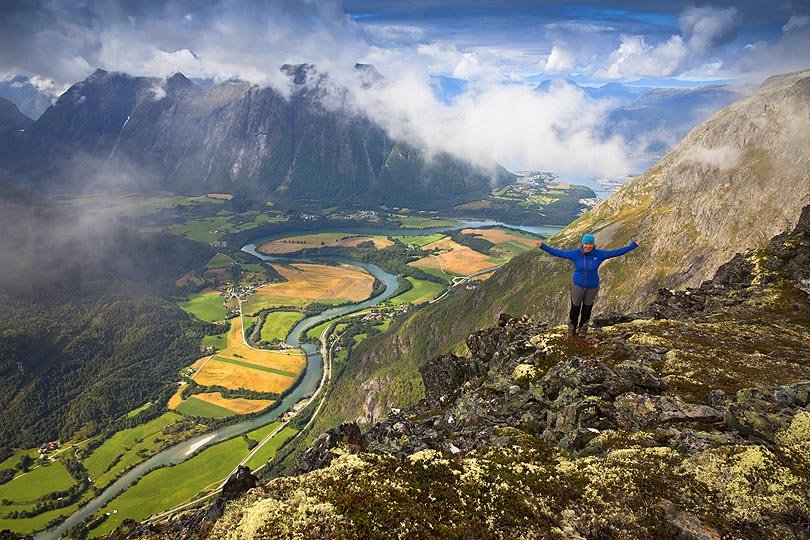
Yes, it was a bit disappointing that we climbed so high and couldn’t see a thing! The mist was coming and going, but never for too long and never giving us full view of what’s around. We knew that straight ahead was Trollveggen (famous Troll Wall we hiked the other day), Romsdalhorn and further to the left – the high rocky ridge of Store Vengetind. We weren’t lucky enough to see them in full glory thou. But, to be honest, from time to time the mist partially cleared and we enjoyed view down to Romsdalen valley and high cliffs just below our feet!

At first the ridge reminded a wide and bouldery plateau, but it narrowed as we progressed, and soon we faced its famous airy sections.
To tell the true, all descents and ascents which could be challenging, were secured with chains. That was very reassuring and helpful. I have a reasonably good head for heights and didn’t find any part of the ridge a problem, however Bea is not as much at ease with heights, but she still found the ridge OK.
Below is a little insight of the airiest parts of the hike:


About half way into the hike, after 5th kilometre, we reached the highest point of the ridge, Mjolvafjellet (1222 masl). It was a wide bouldery area again, lots of space to fit all the keen walkers without disturbing one another. Luckily, the clouds cleared a bit and we were finally able to see the famous Romsdalseggen views: Romsdalhorn standing proud with its summit sticking out of the clouds like, Trollveggen partly hiding in mist, but still very dramatic, and the Romsdal valley – greens and yellows of fields, river Rauma like an emerald ribbon.


I welcomed the thought of reaching the highest point of the trek with a bit of relief and also sadness. Relief, because the hardest part is done and from now it will only be easier. Sadness, because the airy ridge was already behind me and the most exciting part of the walk was over.
I anticipated that from now on we were facing a long and boring descent to Andalsnes. I couldn’t be more wrong! Not only the gentle descent was not boring, in fact it was very nice and varied – with some narrower sections still to come, and another source of drinking water signposted on 7th kilometre.


I liked it a lot up to the final 1.5 kilometre. Then, we reached the very end of the ridge (with a cute stone hut). Awaiting us was a steep and hard descent from over 700 metres over sea level to Andalsnes.
Despite the Sherpa steps (steep stony steps built in 2013 by Nepalese Sherpas) it was a struggle to go down, painful and hard on the knees. While descending we passed Andalsnes viewpoint (steel viewing platform Rampestreken) and even the fantastic views to the fjord did not make it any more bearable. When the Sherpa steps ended, we descended just as steeply thru a forest, used tree roots and rocks as steps.
It was a great relief to finally arrive down at the street level and see our baby camper waiting for us patiently. After 8 hours hike (last hour was the hardest!) we were happy, content and already planning next days journey! We would love to hike Romsdalseggen again, in better weather to be able to enjoy the extensive views to the surrounding majestic mountains.
Update: As of June 2021 there’s now the Åndalsnes cable car. The gondola ride costs 300NOK one way (either up or down) and 450NOK both ways.
How to hike Romsdalseggen ridge Norway
A quick recap of the walking options:
- Vanjesdalsetra to Andalsnes via the Romsdalseggen ridge, distance 10.5 km, time 6-8 hours
- Vanjesdalsetra to Andalsnes via Hognosa (avoiding the airy parts), distance 13.5 km, time 7-9 hours
- walking opposite direction, Andalsnes to Vanjesdalsetra is not recommended unless there is somebody coming to pick you up. The dedicated bus does not take passengers back to Andalsnes. Also, as the walk would start from sea level, there would be considerably more overall ascent.
Romsdalseggen hike map

Romsdalseggen camping information
After the hike we faced the daily dilemma of finding a place to sleep. Romsdalen is a bit tricky to find a spot to stay off-grid.
There is one good spot where wild camping is not forbidden – car park next to Trollveggen Besokssenter along road E136 (it’s large, there are large log-wood tables on the side and a toilet available at Trollveggen Stasjon 7.00 – 21.00 just a 100 metres away).
Along the nearby Trollstigen road (road number 63) it’s hardly possible to find a decent wild camping spot between Trollveggen Centre and Andalsnes. There are two campsites thou. We have visited them both and can advise on which one is better.
First one is called Trollstigen Camping. It’s next to the road, well visible from afar, signposted. The reception/cafe and facilities buildings are grass-roofed, there is a large car park. This campsite was costly, 200 NOK (240 NOK with electricity).
We chose to stay at the other campsite, Trollstigen Resort. It was located a bit further, on the junction of road 63 and 174, in Soggemoen, literary 5 minutes drive further. The buildings were not so well visible from the road (entrance to the campsite is just around the corner, from road 174, easy to find) This campsite had a wow factor. Apart from decent facilities, good campground and huts, very friendly staff, they also provided (free of charge) fire wood for grills and bbqs (many, located in all parts of campsite). Wi-fi signal was very good even thou we camped in the furthest corner of the grassy area. Not to mention the price, which was 175 NOK for a camper (electricity included). If we are ever in the area again we will definitely stay in the Trollstigen Resort! Highly recommended.
What we loved about Romsdalseggen hike
The views to Troll Wall and picturesque Romsdalen valley were spectacular (weather and clouds permitting). Romsdalseggen ridge is a very varied walk, interesting and enjoyable till the very last kilometre. We would love to hike it again!
LOOKING FOR OTHER AMAZING HIKES IN WESTERN NORWAY?
If you’re looking for other hiking ideas in Western Norway, check out these ones!!! All include detailed route descriptions and maps:
PREIKESTOLEN – hike to the famous Pulpit Rock over Lysefjorden! It’s only a short journey from Stavanger, but provides views and hiking experience that will stay with you forever!
SAKSA – the best hike in Sunnmore Alps! Hike to Saksa will leave you breathless, not only due to its steepness! The summit views to rocky mountains and deep Hjorundfjorden are a perfect reward for the effort! Ready for a challenge? Climb Saksa’s bigger brother, Slogen!
NIGARDSBREEN GLACIER – see a beautiful glacier up close! This easy walk in Jostedalbreen National Park will take you directly to the ice edge!
*Level of difficulty explained: 1– easy walk, mostly flat 2-easy hillwalk, good path 3-moderate, possible some steep sections 4-long hillwalk, possibly some scrambling involved, possibly pathless 5-difficult, possibly pathless, long, requires technical skills
NORWEGIAN DIFFICULTY LEVEL EXPLAINED: GREEN – easy , BLUE -moderate, RED – demanding, BLACK -expert
