
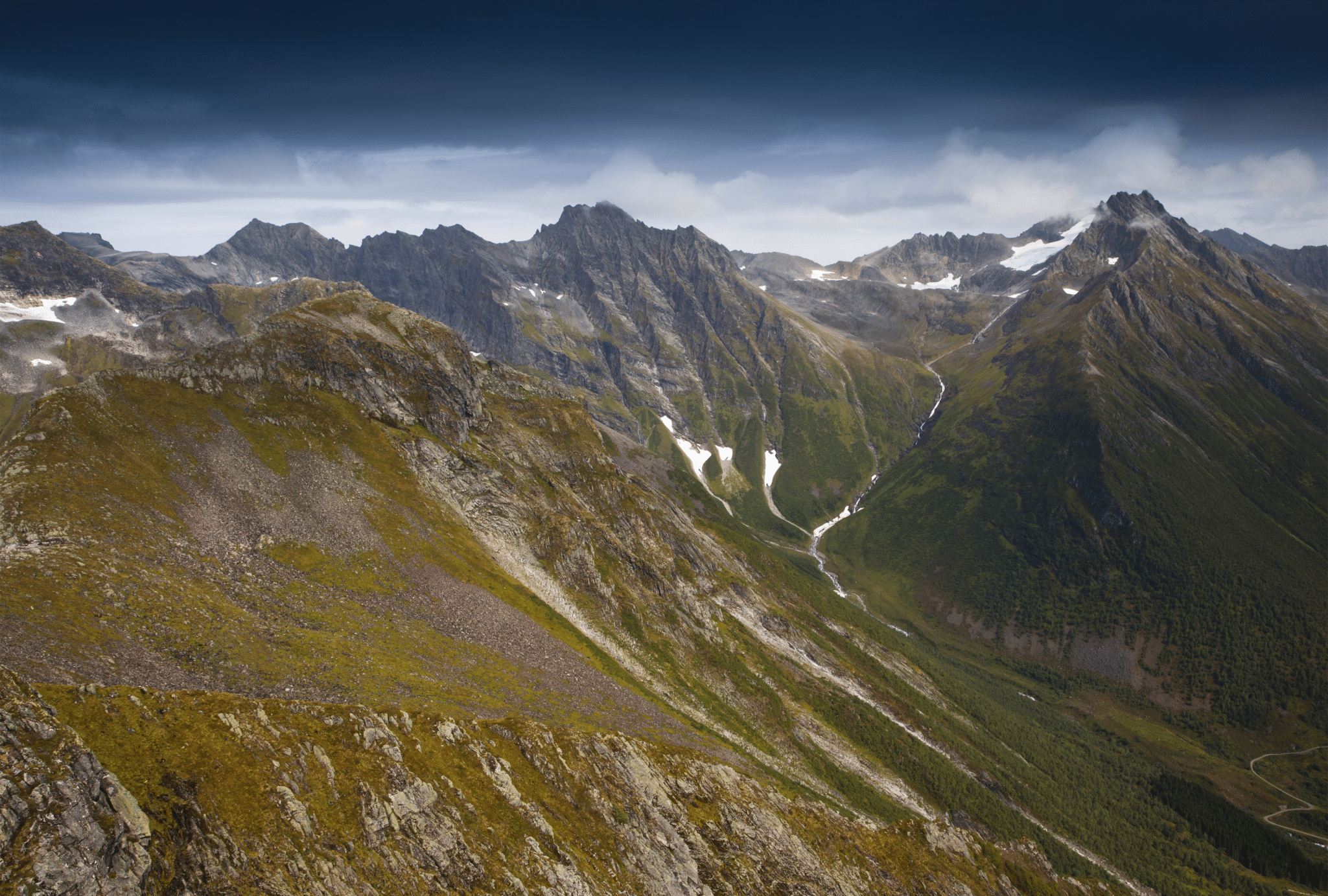
Previous day we’ve been hiking to Mount Saksa (read all about it!) and felt very encouraged to explore the area further and hike another magnificent mountain in Urke/Oye. Slogen Sunnmore Alps (1564masl) was a natural choice because it is the highest mountain in Hjorundfjorden area, it’s famous for astonishing panoramic summit view as well as a challenging, rocky section just below the peak. Let’s be honest, everybody wants to climb the highest mountain, it’s just human nature! Slogen, however, proved to be more than just a bigger brother of Mount Saksa (it’s 500 metres higher, but also steeper, rockier, harder), this mountain definitely gave us a lesson on importance of carefully planning the day. It also reminded us what we love the most about hiking- the challenge, the sweat but also the views, chilling out at the wonderful vistas, fresh air, connecting to nature… it’s not only about reaching the summit and standing proud on the mountain top, but the experience as a whole.
There are three routes up Slogen, starting from Urke and Øye. The routes vary in difficulty level, climbing time and view. Information on each route can be found at the bottom of page. We have opted (unintentionally) for the hardest ascent, route no 1.
Hiking trip to Slogen fact sheet

- Height: Slogen 1564 masl
- Total time: depending on a route taken, please see bottom of post
- Total distance: depending on a route taken, please see bottom of post
- Parking: depending on a route taken, please see bottom of post
- Level of difficulty: 4/5 – long hillwalk, some scrambling involved, steep sections. Norwegian standards: RED – demanding and BLACK – expert – depending on a route taken, please see bottom of post
- Slogen weather: Slogen weather forecast
- Which map: Hjørundfjorden nordeca r/v (click here to buy)
How to get to Slogen
Slogen hike starts in Øye. The village is very easily accessible by car as well as bus/ferry
Getting to Slogen by car, driving from south: take road 60 direction to Hellesylt, turn left into road 655 in Tryggestad, drive towards Lekneset. The distance between Urke and Øye is 5 km.
Getting to Slogen by car, driving from west: take road E39 towards Orsta, then in Orsta take road 655 to Saebo. Take a car ferry from Saebo to Lekneset, when in Lekneset continue along road 655 to Urke/Øye.
Getting to Slogen by bus/ferry: check out local ferry operator Fjord1 website for timetable. You can take the ferry without the car to Leknes, or take the car with you to Urke/Øye.

Slogen Hike
Oh, how much we wanted to repeat the success of previous day’s hike, Mount Saksa (read all about it, here)! We felt so happy, energised and completely in love with Sunnmore Alps. Taking advantage of the weather we planned to conquer Slogen. We also were very keen on this mountain as the hike starts in Øye, only 5 km away from our campsite.
The morning was glorious and somehow we felt so chilled enjoying breakfast outside, we didn’t bother to start the day early. Unfortunately Bea didn’t feel very well and we took our time, waiting to see if she gets better or we should change plans for the day and stay put. After some time we decided to give Slogen a go. We only left the campsite between 10am and 11am, which for our standards was extremely late.
I remembered that previous day, while driving to Urke, we actually noticed a designated car park for Slogen, therefore without much thought (regrettably) I kind of programmed my inner sat nav for that car park… and completely ignored the fact that we actually wanted to hike Slogen via Patchellhytta hut. How typical of me!
In no time we arrived to ‘Slogen’ designated car park just outside of Øye, it was signposted from the road, right into my face. So again, without much thought, I parked our mini-home in a nice shady space and was eager to start the hike.
It’s a relatively large private car park, charge 50 NOK/day, paid to an honesty box. There also is a tap with spring water and a small toilet available.

Geared in comfy hiking boots, hiking poles, maps as well as lots of water and food we left the car park, crossed the road and found a little signpost ‘Slogen’ pointing to a small path between houses. The path passed between dwellings and widened into a well-defined track, heading towards tall spruces. It followed treeline briefly before turning sharply left, further into the woods.
I consulted the map, but did not realise that we were on another path as both; direct route to Slogen and to Patchellhytta hut begin exactly the same.
Only when we began the steep climb I started having doubts about the route, I expected the path to follow a small stream, but there was no running water visible anywhere. And the path was very steep, much steeper than I expected it to be.

I heard Bea muttering, she was very concerned about the path. No wonder, I thought, it was extremely steep, muddy, my feet were getting entangled in ancient spruce roots. Climbing such trail is difficult, but descending it would be even harder. How will we even manage to get down this way?!
Then I decided it was time to share THE BAD NEWS with Bea, so I shyly mentioned that we might actually be on a wrong path. To my surprise Bea only replied that she has already realised it too, and how on earth we are going to get down this way (!?), obviously she would never even consider this as a return path!

So there we were, hiking the steepest route up Slogen mountain, dreading the way down already. Thanks goodness, after about 1 hour climb the trees thinned, path quality improved, we complained less! It was still very steep thou and we were becoming a bit tired, Bea wasn’t feeling well again. To be honest the day started great but since we arrived to (wrong!) car park all was going down the hill. Only as a metaphor, of course. In real life we were going up the hill, and a damn steep one.
But it wasn’t all bad! There were some very nice spots along the trail too, so despite having a hard time we actually enjoyed the hike. There was, for instance, a viewpoint towards the fjord, Urke village and further, to Saksa. What was especially amazing about that little viewpoint? In that particular spot we could rest not on the thick logwood bench (Norwegian classic), but on a hammock! There it was hung between the two birches. I couldn’t resist (what a surprise!) and had a long lie there. I have never experienced such thing, relaxing on a hammock and looking at the fjord and distant mountains, I simply loved it. I could even see Saksa’s twin peaks. It won’t be to anyone’s surprise then I couldn’t force myself to get off it and face the steep trail again.
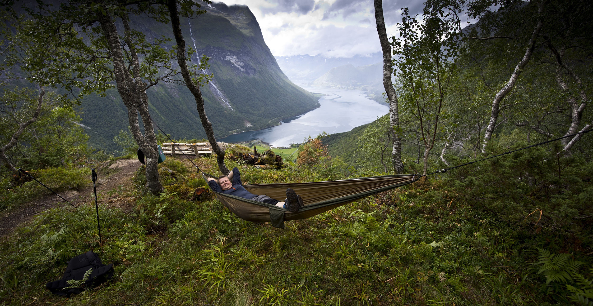
Finally we climbed over a tree line. The views opened even more. It was truly amazing. Looking east we could see the length of Norangsdalen, to the west we enjoyed view over Hjorundfjorden, great Helgaa waterfall, Urke village, Saksa and far to Orsta mountains.

In front of us was the massif of mighty Slogen mountain, its steep rugged slopes and sharp rocky ridges. Was it intimidating? Maybe a bit, yeah. I think that once we actually saw what’s still ahead we started realising that we did not have enough time to conquer the summit and then return before the nightfall. We were very disappointed at the thought of giving up further climb.
We both felt it has been a slow climb. We were especially disheartened by watching other hikers, passing us at speed of a lightning. We were very impressed by Norwegian walkers, it seemed they almost run up the hill, no visible signs of effort, most of them speedy like rockets! And there were the two of us, on an ‘unintended path’, dripping with sweat, feeling a bit unwell and sad about the time running out.
It took some deciding, but we thought that it just wasn’t meant to be that day. We felt we would probably have to climb for another 2 hours to reach the summit and then return, best case scenario, 3 hours.
Saying that, I also felt very happy to have reached that far and to have been able to enjoy these incredible views. My heart was singing on the memory of ‘hammock break’ and I knew that descending the same way, I will have another chance to enjoy it!
The all important question
After all, what’s the most important to us while outdoors? Why do we hike? Everybody will give different answers to that, I’m sure. I guess we all do it to reach the summit, of course, to conquer, to prove to ourselves that we can do it. But is hiking in thick fog and mist just as enjoyable? Would we hike just for the sake of climbing a mountain, knowing that we will end up in a total white out when reaching the top, and no views whatsoever? Would we still hike then?
For Bea and I the answer is very simple. We are both suckers for the views. We are passionate about outdoors and hiking, but just as much we love photography… and having fantastic summit views helps a lot to feed our passion! We both also love spending time outdoors, hiking, walking, talking. We love to feel sunshine and wind on the skin. We love the experience of the stunning outdoors!
I’m saying all this because I believe that all outdoor lovers are a bit similar. We all love the experience. Failing to conquer the summit is not the end of the world, and it does not necessary spoil the day. Always remember there is that ‘hammock break’ awaiting you half way down, remember the views you have already seen, the people you have already met.

It does not happen very often we get beaten by a mountain! One has to know when to withdraw, thou… We retraced our steps down, luckily we found the descent less difficult than anticipated. Also, the same as previous day on Saksa, we picked up some wild mushrooms along the trail, this time the forest was exceptionally rich in chanterelles. It’s not difficult to guess what was for breakfast next morning?
Once we returned down to the car park we analysed carefully where we went wrong that day: late start, wrong car park/wrong path, we lost too much time enjoying (too long) breaks along the trail.
There was a way to make the day even more pleasant, still! On the way back to campsite we took a short break in Maude (half way between Øye and Urke), at the small beach. Bea hastily jumped into icy fjord and enjoyed a swim in crystal clear waters. I chickened out (water way too cold for me!) but I was happily watching her from the shore 🙂

I regret that we didn’t manage to reach the summit that day. I feel, that instead, we should have stayed put, relax and enjoy the sunny day somewhere in a valley or having a long walk along the fjord and hike Slogen mountain the next day. I’m sure that after such a little break, the Slogen hike would have a totally different ending, and we would enjoy it even more. I’m sure that on the next visit in Sunnmore Alps we will ensure to have a lot of time to enjoy the hikes or relax if we feel like it! I wish we stayed longer in Urke before rushing to the next adventure, hiking Troll Wall (Stabbeskaret) in Trollstigen area (read all about it here!)
Well, next time!
As I mentioned above, Slogen can be climbed by three different trails. Two of them start in Øye and the longest one starts in upper part of Urke village. Please see below for detailed information and a map.
*************************
Hiking Slogen – route 1
direct route, shortest but the most difficult climb
Level of difficulty: 4/5* (Norwegian standards BLACK = expert) Total time: approx. 8-10 hours (total length 8km, return the same way)
Path begins at: Øye (dedicated, signposted car park at Norangdal road, near house no 147) Click here for directions
Marked path: yes
There is a dedicated car park marked ‘Slogen’, it is signposted from main road, located at the southern side of the road. Nearest house number is 147. This car park also serves a small water pump station, hence a tap with fresh spring water is available (and a toilet). There is a charge for parking there, 50 NOK per day, paid in a provided envelope to an honesty box.
Trail no 1 is the shortest route up Slogen mountain, but the most difficult one (Norwegian standard difficulty level BLACK – expert). The path is rugged, eroded, extremely steep. There is additional difficulty in the shape of countless tree roots running across the path. About half way up to the summit ridge the path emerges from the trees into an open space and finally one can see what lies ahead. Final section to the summit ridge is especially rugged and requires extreme care. When finally on the summit ridge, turn left towards the towering rock of Slogen’s peak. It’s the most difficult part of hike, requires good head for heights.
Norwegian sources mention overall climb time (car park to summit) 3 hours, but I can only comment that it’s very optimistic. I would probably add another 1.5 to 2 hours, making it an overall climb time 4.5 to 5 hrs (one way).

*************************
Hiking Slogen – route 2
Via Patchellhytta hut
Level of difficulty: 4/5* (Norwegian standards RED = demanding) Time: approx. 10-12 hours (total length 10km, return the same way)
Path begins at: Øye/Skylstad (Norangdal road, near houses no 255 and 260) Click here for directions
Marked path: yes
There is a dedicated car park marked ‘Patchellhytta’, it is signposted from main road, located at the northern side of the road. Nearest house numbers are 255 and 260. There probably is a parking charge as it is a ‘dedicated’ car park on private land.
Trail no 2 starts at the east side of house no 255 therefore it’s necessary to exit the car park and follow the main road west for about 2 minutes. There is a small dirt road at the side of house 255, it leads between the fields and over a small bridge. Cross this bridge and turn right at the fork. Follow the river for a bit, ignore the first fork to the left and continue ahead. The dirt road will soon turn left and change into a narrow track. This is the way. It follows a small stream (Brekkelva) all the way to the Patchellhytta hut.
First half of the ascent is very steep, sheltered by spruce forest. As soon as it emerges into an open space, it eases. Patchellhytta hut is located on a small plateau between mountains, surrounded by such giants as Smorskredtindane, Brekketindane, and of course Slogen. It can be used as a great base for exploring the area, in fact it’s very well-known just for that.
From the hut, take the obvious path towards towering summit of Slogen (to the west), ignore the first fork to the right and take the next left – path ascending steeply to Slogen summit ridge. Follow the ridge straight ahead to the rocky summit of Slogen.
It is said that hiking time from car park to Patchellhytta hut is 3 hours and further, from hut to Slogen summit additional 2 hours. But, as I mentioned in description of route 1, I found Norwegian timescales a bit underestimated, so I would probably allow 3.5 to 4 hours hiking to the hut and about 3 hours from hut to the summit, making it an approximate 6.5 to 7 hours one way.
*************************
Hiking Slogen – route 3
The longest, but easiest ascent
Level of difficulty: 4/5* (Norwegian standards RED = demanding) Time: approx. 10-13 hours (total length 12km, return the same way)
Path begins at: small car park in Myrsaetra (upper Urke), at a small dam. Click here for directions
Marked path: unknown
Route no 3 is the longest, but easiest way to climb Slogen. It also is the most varied and scenic route, as it passes six lakes and ponds before making a final turn to climb to Slogen’s summit ridge, from the north.
There is a small car park in Myrsaetra (upper Urke), near the dam. There are two roads leading to the dam. First, Haugemyrvegen, is a rough unpaved road which can be accessed by turning north from main road (Urkevegen) opposite the house no 234. The other road, Urkegjerde, is a paved narrow road, winding up Urkedalen, towards Haukassaetra, and further it meets the rough road, Haugemyrvegen at the very dam. The car park itself is on the north side of the small bridge, just before the dam. From the two roads I would definitely choose the second option – paved road which is accessed from Urke ‘centre’, between the campsite and grocery shop.
Hiking trail starts at the road T-junction, between the bridge and the dam. It roughly follows the stream (which itself is interesting as it flows deep in a small gorge). As the vegetation turns a bit more tundra-style, the path comes closer to the stream and finally crosses it (there is a small bridge). The path forks there. Take the fork that continues following the stream and steadily climbs up. Soon it passes the first pond, Litlevatnet. As the name suggests, it’s just a small pond, seen from a bit afar. Very soon after, there is another pond along the way, Storevatnet (a bit bigger). The path then crosses a small stream (ford) and approaches Isavatnet, this time it’s a proper lake, located directly under the rocky tower of Slogen. There are some more small streams to cross and tiny ponds to enjoy before the trail climbs a bit up, to join the main Slogen trail coming from Patchellhytta hut. Turn right there, climb steeply to the Slogen rocky ridge and follow a rocky path to the summit.
Time-wise, this approach is the longest and it could be a good idea to break it into a two day hike, with a sleepover at Patchellhytta DNT hut. It is said that hike from the dam to the hut takes about 5 hours, plus additional 2 hours to the summit. To be safe I would allow about 8 hours to the summit only.


Wild camping and campsites information
There is a decent campsite in Urke, price for a campervan 200 NOK (250 NOK with electricity). Prices valid in August 2018. We really enjoyed our stay there, as the staff and atmosphere are very friendly. There even is a small herb garden within the campsite and we were able to pick fresh herbs for our dinner!
There aren’t any spots suitable for wild camping along the fjord, however we encountered some good overnight camping places along Norangsdalen, there were some quiet car parks and bays.
What we love about hiking Slogen mountain
We loved the challenge, the views over Hjorundfjorden towards Risenosa group of mountains and abundance of wild mushrooms along the path!
*Level of difficulty explained: 1– easy walk, mostly flat 2-easy hillwalk, good path 3-moderate, possible some steep sections 4-long hillwalk, possibly some scrambling involved, possibly pathless 5-difficult, possibly pathless, long, requires technical skills
NORWEGIAN DIFFICULTY LEVEL EXPLAINED: GREEN – easy, BLUE -moderate, RED – demanding, BLACK -expert
