
After a week spent in Lofoten archipelago we were finally ready to continue the journey. As we were travelling along Norwegian coast, west to east, it felt very natural to take the ferry from Fiskebol on Lofoten to Melbu, to explore Vesteralen islands.
Having arrived to Melbu we did a quick shopping in a supermarket near ferry harbour (you cannot miss it). Then we drove a bit further to find a nice spot to prepare breakfast with a view. We always welcome a cup of good morning coffee; but that day was special – we had salad for breakfast! Who would think that we got excited about having a salad for a breakfast!? But then remember, in a country where cucumber costs £2.20 and a pack of mixed salad leafs is £3.50 salad is a rare treat!
First impression of Vesteralen
Having come from Lofoten, you would think that it’s hard to be impressed with Vesteralen, that the islands are less interesting. Thinking that, you would be totally wrong! In fact, Vesteralen is a very varied archipelago: rugged mountains, white beaches, vast marshlands and swamps, and colorful villages – all of that you’ll find on the archipelago.
Vesteralen islands have a couple of advantages over Lofoten – they’re less popular with tourists, and therefore much quieter; a perfect destination for those seeking relaxed atmosphere, far from madding crowds.; also their climate is milder.
How to get to Vesteralen islands
Vesteralen are connected to Norwegian mainland by Tjeldsundbrua bridge along road E10. There also are bridges and tunnels between the islands, hence visiting archipelago by car is really easy, without the need to take ferry.
Despite good road connection with mainland, many visitors (including us) reach Vesteralen by ferry. On our journey in Northern Norway, we arrived to the archipelago directly from Lofoten; we took Fiskebol to Melbu ferry operated by Torghatten Nord (timetable). A week later we left the archipelago directly to Senja, by ferry from Andenes to Gryllefjord (timetable). Please note that some ferry connections operate only in summer, other greatly decrease service frequency in low season, therefore it’s always best to plan your journey in advance.
Alternatively, Vesteralen can be reached by Hurtigruten ferry. Hurtigruten offers cruises along Norwegian coast, they also can offer transfers between specific ports (sailings to Sortland in Vesteralen). Check out their website for detailed information.
Although there are airports in Vesteralen, they mostly serve local traffic. The easiest way to fly in, is coming to the largest airport in the area – Harstad/Narvik (website), then taking the Airport Bus to Sortland in Vesteralen (bus journey time 2 hours).
Why you should visit Vesteralen islands? Things to do during your visit
About Vesteralen islands
Beautiful hikes in Vesteralen
Andoya Scenic Route – scenic tourist route in Vesteralen
Villages and towns in Vesteralen
Whale watching in Vesteralen
Sami experience in Vesteralen
See northern lights and midnight sun in Vesteralen
About Vesteralen islands
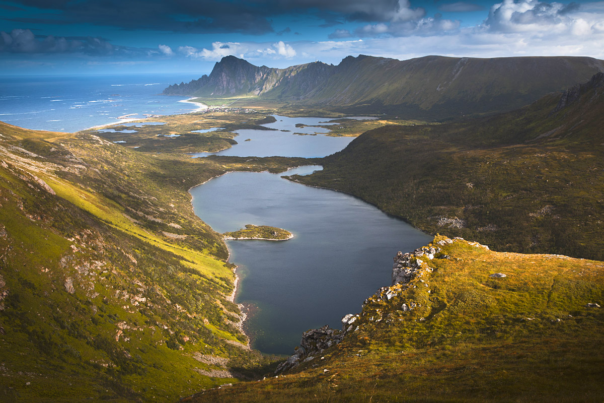
Vesteralen is a beautiful archipelago of several islands connected by bridges, in Northern Norway. Although it’s located between Lofoten and Senja, its landscape greatly differs. Most of Vesteralen mountains are not as rocky and sharp (apart from Moysalen National Park), but rather rounded. Also characteristic to Vesteralen are the vast marshlands and swamps, bordered by hills and ocean.
The archipelago makes a perfect destination for those who seek solitude and peaceful, relaxed ambience. It’s less known and visited than its famous sibling – Lofoten, sparsely populated – its few towns and villages are located mostly along the coast, islands’ interior is pretty much wild.
Vesteralen are also hiker’s paradise! Numerous, stunning hiking trails run thru its wild mountains where everyone would be able to find a dream trail for themselves; whether an easy walk to local viewpoint or a challenging climb to Vesteralen’s highest peaks, over 1200 masl (Møysalen).
Another unique fact about Vesteralen Northern Norway is the proximity to underwater continental shelf. Why is this so special? Rich in nutrients Atlantic sea currents bring plenty of fish; this attracts various species of sea predators and, most importantly – whales! Hence, Vesteralen is one of the best destinations in the world for whale watching, you’re almost guaranteed to spot whales any time of the year, even on short trips!

Beautiful hikes in Vesteralen
Visit to Vesteralen archipelago can’t be complete without a hike, or two!
Below, we’re sharing three hikes. These three were not chosen at random; each of the featured hikes is different in length, landscape and level of difficulty; also, they’re located in different parts of Vesteralen. Hence, pick the most suitable hike for you and enjoy nature of Vesteralen!
Dronningruta – northern Langoya, difficulty: moderate to hard
Matinden – Andoya, difficulty: easy to moderate
Hallartinden – southern Langoya, difficulty: easy

Dronningruta
Location: northern tip of Langoya island, village Sto.
Total length: 15 km Total time: 6 hours
Level of difficulty: moderate – long ridge walk (Norwegian – RED, demanding)
Highest point: Sorkulen 518 masl
Dronningruta is the best known mountain hike in Vesterålen archipelago. Also known as The Queen’s Route, this 15 km trail should be on ‘to do’ list of every keen walker visiting Northern Norway.
We recommend hiking Dronningruta trail from village Stø, on the northernmost tip of Langoya island.
The hike begins by steep climb to the ridge; however once on ridge the trail follows a horse-shoe of gentle summits and is an awesome ridge walk.
As Dronningruta is the longest hike we completed on Vesteralen, we prepared a separate post about it; including directions, available car parks, detailed trail information and a hiking map.
Check out detailed information on hiking Dronningruta from Sto.
Return to Beautiful hikes in Vesteralen

Matinden – Andoya
Location: Andoya island, near Stave (parking directions)
Total length: 7.5 km Total time: 3 hours
Level of difficulty: easy hill walk (Norwegian – BLUE, moderate)
Highest point: Matinden 408 masl
Matinden is a fantastic viewpoint, one of the best in Vesteralen. Standing on its top, we admired never-ending ocean to the west and mountainous landscape to the east. To the south, at the foot of Matinden is a small sandy beach; to the north – a lush green valley and Bleik (a small village with and a beach).
Hike to Matinden is a perfect combination of an easy hill walk and coastal walk.
We opted for the shortest approach to Matinden; left the car at small, free car park along road 976 (exact location and directions).
Initially, we followed a muddy path climbing steeply to the first hill of the day – Nonstinden 340 masl. Once on Nonstinden, we already saw Matinden in the distance before us and simply followed one of many paths running across grassy plateau, to Matinden summit. The very last section before reaching the summit is a bit steeper again, but it’s only a very short ascent to the top.
Standing on the very edge of rocky cliffs over the ocean was spectacular feeling; we highly recommend making an effort to climb to this little viewpoint.

Matinden can also be hiked from nearby village, Bleik (car park, directions). The signposted trail follows a coastal path at first; then steeply climbs directly to Matinden summit. Therefore, if you’re based in Bleik, you might find this option more appealing, although a bit longer (10 km, return).
See more photographs from Matinden, below


Return to Beautiful hikes in Vesteralen

Hallartinden
Location: sountern end of Langoya island, near Bitterstad (directions)
Total length: 4 km Total time: 3 hours
Level of difficulty: easy hill walk (Norwegian – BLUE, moderate)
Highest point: Hallartinden 530 masl
Hallartinden hike starts at a small car park near Bitterstad village (directions), just past the bridge connecting Hadseloya and Langoya. There is a 20 NOK charge for parking.
Although the trail is not signposted, it is easy to follow; look out for red ribbons tied on tree trunks and branches, they will show you the way, if in doubt.

From the car park we first followed a small country road, running thru beautiful evergreen spruce woodland and climbing gently. Very soon we came to an opening, a large heather meadow. The day we hiked to Hallartinden was very hot; as soon as we spotted bushes heavy with blueberries, we were ready to have a break, pick berries and enjoy the smell of warmed woodland. We continued along the forest track for a moment and soon the path forked; we turned right and started ascent to Hallartinden ridge.
Apart from berries, we also spotted tons of wild mushrooms; going up we already planned to pick some on our return way. Bea and I are great wild mushroom enthusiasts, they’re amazingly fragrant and tasty, make for a perfect addition to any dish. Actually, we picked so much of them while coming back from Hallartinden, they made a great dinner, and next day breakfast!
Towards the top path become steeper, but at the same time views kept us distracted and allowed for some breaks to catch the breath.
Hallartinden is a great and popular view point – a good opportunity to meet friendly locals.
We hiked on a beautiful day and had a chance to see sun blushed Lofoten Islands in the distance. In fact it was the only day we have seen sun over Lofoten! How ironic that sunshine came to Lofoten on the very day we left the archipelago!

Once on the summit of Hallartinden, we put our names in ‘guest book’ (check out 28/8/18) and enjoyed view over Sortlandsundet, Hadseloya island, and further to high mountains of Møysalen National Park. To the north, at the foot of Hallartinden is small Vikdalen valley, dotted with lakes.

The day was amazingly warm hence we were in no hurry to return to car park. Instead, we continued along the wide, gentle ridge, to the next summit – Vikfjellet 516 masl. Only then we retraced our steps back to the car park, picking up berries and mushrooms as we walked.
Handy tip: if you visit this viewpoint in late summer take a container for blueberries and mushrooms (if you feel confident picking wild mushroom) – they’re plentiful on Hallartinden, you’ll be spoilt!
See more photographs from Hallartinden, below


Return to Beautiful hikes in Vesteralen
OTHER EPIC ROAD TRIPS IN NORWAY!
Helgelandskysten – scenic tourist route along Helgeland coast, with fine hikes and several stunning islands to explore!
Lyngen fjord- drive with views to dramatic alps of Lyngen area, just north from Senja. Enjoy beautiful hikes and visit charming villages.
Lofoten islands– check out our 7 day Lofoten itinerary, filled with hiking, stunning beaches and visits to quiet villages
Senja – also known as ‘Norway in miniature’! Discover remote villages, enjoy numerous stunning hikes and chase northern lights!

Andøya Scenic Route – National Tourist Route in Vesteralen
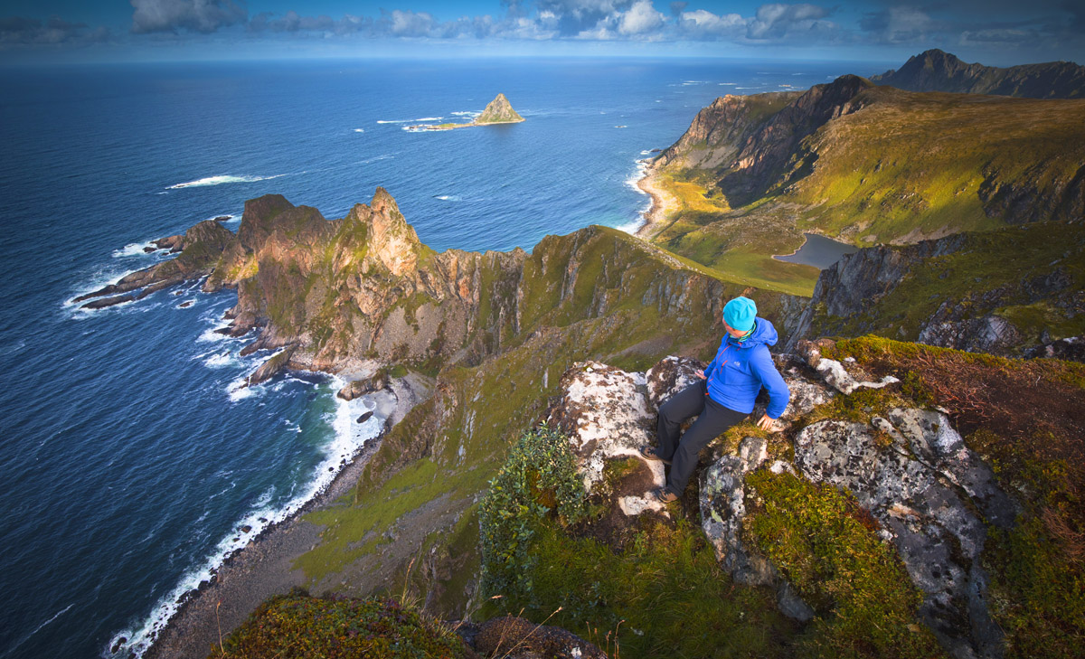
Andoya is one of the most beautiful islands of Vesteralen. Being northernmost island of archipelago, it also is most characteristic one. Therefore, in 2012, an official scenic route was marked along the island, and named Andoya National Tourist Route.
The route is about 50 km long and runs from Bjornskinn in the south of island, along western coast, to Andenes – the northernmost tip of Andoya. You could say it’s a relatively short distance and could be driven within an hour, but you do not want to rush it, I promise you. Instead, make sure you have at least a day – you’ll want to stop countless times to take photos, or explore small beaches, or visit villages along the road.

We have followed this scenic route while visiting Vesteralen, and can’t wait to share the experience with you, check out the photographs below!
Our experience of Andoya National Tourist Route
We set off from southern end of Andoya and headed west, followed a small road squeezed between ocean and rugged mountains.
Andoya scenic route took us thru flat grassy marshlands, over wild and bare rocks of Andoya’s western coast, below green, moody mountains. We also passed a couple of beaches; the most beautiful were Bø, Sandvika, Mellaberget and Bleik.

We can’t encourage you enough to do a hike or two while driving along Andoya scenic route. There are several smaller hills worth visiting, however we especially recommend one – Matinden.
Located exactly half way between Stave and Bleik, Matinden is located directly over ocean and an amazing viewpoint. Check out detailed hike description in ‘Beautiful hikes in Vesteralen’ section (above).

Also the villages we passed along Andoya scenic route are worth a mention. Having previously visited Lofoten, Vesteralen villages seemed totally different, more remote. Instead of red and yellow rorbu (in Lofoten), Vesteralen dwellings are colourful (all colours!), architecture-wise reminded us Norwegian mainland.
Some villages, like Nøss, consist of only a couple of houses; we sometimes wondered how these locations are even marked on the map!

Did you know that there is a Space Centre in Vesteralen? If you ever fancied checking out a space ship, you can do it near Andenes (directions and website)! ‘Space Ship Aurora’ is open to visitors!
If you suddenly fancy having a dip in an ‘outside’ hot tub, visit Stave Camping and Hot Pools! Staying at this campsite you’ll be able to enjoy a bath with the view to mountains and ocean!

The only thing we weren’t particularly fond of while following Andoya National Tourist Route was the number of military purposed constructions and buildings, especially coming towards Andenes. On the other hand, passing these constructions we felt like taking part in a scene of sci-fi movie!
All this (and even more) along Andoya scenic route!
See more photographs from Andoya Scenic Route, below


Villages and towns in Vesteralen
Although our main focus while visiting Vesteralen were mountains and other wild lands, we also visited couple of villages and towns. Typical architecture in Vesteralen are colourful wooden houses and lodges, you won’t, however find rorbu on the archipelago (red or yellow fishermen’s houses typical to Lofoten, built on water).
We arrived to the archipelago by ferry from Lofoten, landed in Melbu, a village on Hadseloya island. Melbu is a home to one of Norway’s largest fish processing plants and Fishing Industry Museum. There are also 2 supermarkets, petrol stations and a bakery.
Sortland is the largest town on Langoya island. It’s the beating heart of Vesteralen, with numerous cafes, restaurants, shopping centres. What was the most important for us, in Sortland we managed to find an industrial gas distribution company, which was happy to fill our 2kg gas bottle we used for cooking. Finding Varmeservice AS on Markveien (directions) helped us a lot as we were just about to run out of propane.

Myre was the village nearest to campsite we stayed (Oppmyre Campsite). We found shops, cash machine, bank and cafes during our short visit. The village is beautifully located over the sea, overlooking Sommaroy island.
Stø is a small fishing village on the northern tip of Langoya island. It’s a small settlement squeezed between the ocean and rugged mountains. Despite its remote location, Sto is well known for whale watching safaris; also the iconic Dronningruta hike starts just past the village.
Bø, Midtgard and Bleik – these small villages are located along Vesteralen Scenic Tourist Route. They’re perfect spots for a short break and a beach walk (especially Bleik).
Andenes is located at the northernmost end of Andoya island, further to the north are only endless waters of Atlantic Ocean. The village is an important spot on Vesteralen map – there is an airport and large (as per ‘far north’ standards) harbour. Also, the village is one of best locations to take a whale watching boat tour. To the south from Andenes are beautiful sandy beaches, albeit small, as well as Andoya Space Centre where you can visit a Space Ship Aurora.
Andenes was the last settlement we visited in Vesteralen; we headed by ferry to our next destination – Gryllefjord in Senja.

Whale watching in Vesteralen
Vesteralen archipelago is one of the world’s best locations for whale watching!
How is that? The archipelago is located in very close proximity to underwater continental shelf. Rich in nutrients Atlantic sea currents bring plenty of fish, this attracts various species of sea predators and, most importantly – whales!
Whale watching trips can be taken from Stø (small village at the northern tip of Langoya island) or alternatively from Andenes (northern tip of Andoya island), all year round. You’re almost guaranteed to spot whales during a boat or rib trip in Vesteralen, many operators offer another, free trip if you don’t encounter whales during the sailing.
It is important, however, to do a bit of research before deciding on whale spotting trip. Choosing a tour operator and time of the year are probably two main factors.
As many other tourists visiting Vesteralen, I was very excited on the thought of whale spotting trip. I was even ready to swallow the high price for such sailing, which in 2018 was just shy of 1000 NOK per person. However, I have decided against it. The reason?
In summer you’re most likely to spot sperm whales and maybe some orcas (killer whale), but I was really interested to see humpback whales. You may think I am being too picky, as being able to see sperm whales’ back fins gently cutting the water, or their tail fin is something many visitors dream of. Fair enough! But travelling long term made us careful how we spend our money. Hence, I will have to come back to Vesteralen another time to give myself a chance to see humpback whales. When would be the best time to see these giants famous for jumping out of water?
Humbpack whales come near Vesteralen archipelago in winter (January to mid-February), killer whales (orcas) are less predictable as they follow herrings movement but are likely to stay till April. Therefore the best time for whale watching in Northern Norway is the first quarter of the year, in my humble opinion. Also, in winter whales come closer to the islands and can be spotted even during a short sailing.

Sami experience in Vesteralen
Although Sami are mostly associated with Lapland, you can experience real Sami culture in Vesteralen. We were very surprised to learn that, in the past, over 90% of Vesteralen fishermen were Sami; we only knew Sami as the indigenous reindeer herders of Lapland and very Far North.
Nowadays, the only Sami farm in Vesteralen is located 4 km north of Sortland, the Sami farm provides a great insight to life of ancient Sami people.
During the visit, you will be able to learn about Sami culture, history, food and get to know some friendly reindeers!
Keep in mind, that the Sami farm is open every year from mid-June to September.

See northern lights and midnight sun in Vesteralen
Northern Norway is one of the best locations in the world to see Aurora Borealis and midnight sun. Aurora Borealis is casually known as northern lights, this phenomenon is one of the most beautiful occurrences we ever witnessed. Although, we have seen it in Scotland on a couple of occasions, the Norwegian experience beat it by the head.
How to see northern lights in Vesteralen
The best time to see northern lights in Vesteralen is late autumn and winter, however good news is – you can see them as early as end of August. All you need is a fairly strong solar activity + clear skies + little light pollution (find a dark place, usually somewhere outside the village).
You don’t have to worry too much about light pollution in Vesteralen, as the small villages are scattered; clear skies + solar activity are the factors you have to keep an eye on. Nonetheless, you can try to spot Aurora Borealis every clear night! However, tracking real time solar activity and northern lights forecast online can come handy (click here).
Before you set to hunt for northern lights, you should know what to expect. Every photograph of colourful bows, beams and coronas just sharpen everybody’s appetite, however not everyone is aware that what we see with naked eye, is not always as bright and colourful. Human eye is not sensitive enough to detect specific colours (unless severe solar activity – then green and purple can be seen with naked eye). What you’re most likely to see while hunting for Aurora Borealis are monochrome (or pale green) bows and beams. Luckily, your camera sensor is sensitive enough to catch all the colours on beautiful photographs.

When is the best time to see midnight sun in Vesteralen
Midnight sun can only be experienced in far north. There are a couple of weeks in summer, when the sun either doesn’t really dip under the horizon, or dips for less than an hour. Then, night sky is bright and it feels like day!
When sky is clear, you can watch the sun set and rise at the same time. This lasts for couple of hours and you can’t really tell when sunset ends and sunrise starts. It’s a magical experience, we witnessed it in Iceland and this memory will stay with us forever (the same with watching northern lights for first time!)

The best time to see midnight sun in Vesteralen is from mid-June to early July.
Interested in other far-north locations? No problem, we have it covered! See midnight sun in: Bodø: 4 June – 8 July, Tromsø: 20 May – 22 July, North Cape / Nordkapp: 14 May – 29 July, Svalbard: 20 April – 22 August, Lofoten Islands: 28 May – 14 July, Arctic Circle in general: 12 June – 1 July
Petrol stations and propane gas in Vesteralen
Petrol stations are easy to find in Vesteralen, you can find them in every other village.
Most importantly, in Sortland we managed to find an industrial gas distribution company, which was happy to fill our 2kg gas bottle we used for cooking. Finding Varmeservice AS on Markveien (directions) helped us a lot as we were just about to run out of propane.

Vesteralen camping
Wild camping in Vesteralen (and all of Norway) is allowed and widely accepted. By law, everyone is allowed to stay overnight at any spot at least 150 metres from nearby buildings. Vesteralen are sparsely populated, therefore it’s very easy to find a suitable wild camping spot for a camper van or a tent – even along the road.
Campsites are plentiful in Vesteralen. On Langoya island there are at least 7 campsites between Sortland and Stø; on Andoya are another 5 camping grounds. Most campsites in Vesteralen are located directly at the seaside.
One thing to note – outside of high season (summer) we recommend contacting campsites to check whether they’re open, before setting off.
Highly recommended campsite. During our visit to Vesteralen we stayed at Oppmyre Campsite (website) and (directions) and can totally recommend it! In fact, we think that Oppmyre Campsite was one of the best we ever stayed. Not only it’s beautifully located at the sea, with views to mountains, but also the facilities were great! Campsite kitchen and living room were very clean and of such high standard, it actually felt like using somebody’s home. We stayed at the campsite for two nights; first evening we chilled out in the living room, listening to music and working on laptop. The campsite is small, owners are very friendly and the atmosphere is relaxed. While driving to the top of Langoya island, we passed at least 6 other campsites, located between Sortland and Myre; we feel, however, that staying at Oppmyre Campsite was worth driving extra miles.
If you suddenly fancy having a dip in an ‘outside’ hot tub, visit Stave Camping and Hot Pools! Staying at this campsite you’ll be able to enjoy a bath with the view to northern Andoya: mountains and the ocean.

