
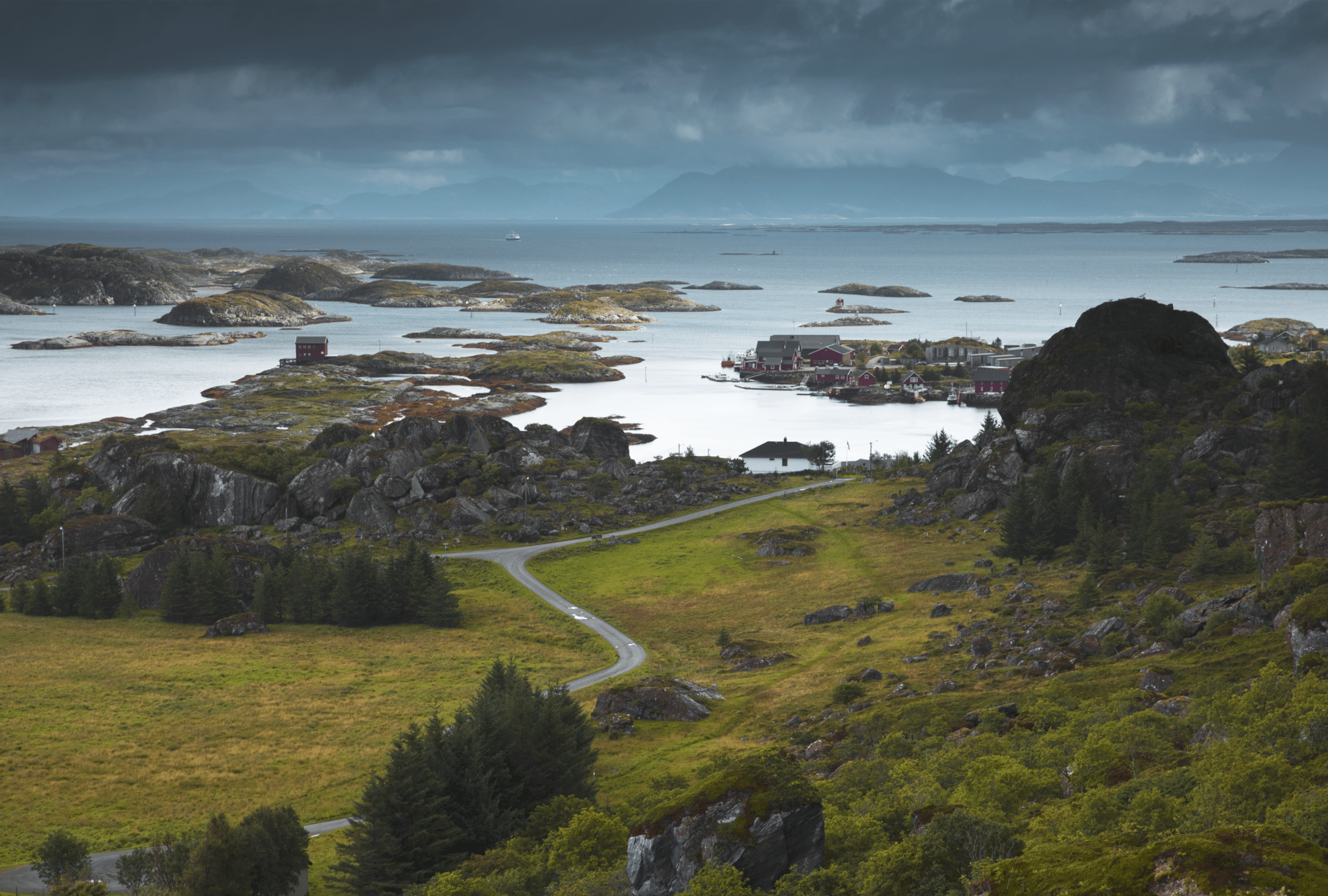
Coast of Helgeland is a beautiful maze of small islands, peninsulas and fjords. Amongst this amazing landscape are Lurøy islands: Sleneset, Traena, Selvaer, Onøya, Lurøya and Lovund, to name only the main ones.
The islands are located just at the arctic circle and often referred to as ‘Arctic Circle Islands’. They’re ideal for a day trip!
Lurøy islands are very similar in character therefore we only picked one to explore. We chose Lovund because its highest point, Lovundfjellet (Litlfjellet) is a fantastic viewpoint over the archipelago; we looked forward to hiking it!

Having arrived to Lovund, we realised that this little island is a home to a large fish factory (salmon farmed in Helgeland is processed on Lovund, then exported across Europe); large lorries cross to Lovund on regular basis. However, stay assured that the fish plant – located near harbour, doesn’t dominate the landscape; once you’re outside the village you totally forget about the industrial side of Lovund.
The island is also known as home to one of the largest puffin colonies in Norway. These beautiful birds easily find place in everybody’s hearts; they’re very special. Someone could joke that puffins are a cross between parrot and a penguin, in fact they’re really charming and birdwatchers’ favourites of northern countries.


Day trip to Lovund Norway – an ultimate guide
How to get to Lovund island
Don’t miss your ferry! Know how to read ferry timetable!
Puffin colony on Lovund
Short hikes on Lovund island
Tale of two chilled hikers foolishly missing the last ferry to mainland
Campsites and wild camping
What we loved about Lovund island

How to get to Lovund island
Lurøy islands are very well connected by frequent ferry and speed boats service, hence easily accessible.
Keep in mind that all the islands are small and best explored on foot, therefore there’s no need to take your car on a day trip to Lovund. In fact leaving your car on mainland will give you greater flexibility – you will be able to choose either ferry or small speed boat to suit your plans or maximise time spent on the island.
Let’s have a closer look at all crossing options.
Ferry from Stokkvagen to Lovund island (timetable) is operated by Boreal Transport. There are several small islands near Stokkvagen, they are all served by the same service, meaning that ferry to Lovund will first call at Onøya, Sleneset before arriving to Lovund and returning to Stokkvagen.
There is also speed boats transport available amongst the islands, click here to find your connection. If in doubt, ask at the harbour – locals are very knowledgeable and will be able to advise on all connections with mainland. Keep in mind that express boat journeys can be rough, hence on a windy day opt for a ferry rather than a small boat.
Going for a day trip to islands, you can leave your car at a large, free car park near ferry terminal in Stokkvagen (directions).
On our trip to Lovund we took car ferry from Stokkvagen in the morning, however, as we foolishly missed last ferry returning from Lovund, we ended up taking a small speed boat to Onøya (via Traena and Selvaer), and then changing for another ferry to Stokkvagen (Torghatten Nord). As complicated as is sounds, figuring it out was possible with kind help of friendly locals of Lovund and boat/ferry crew!

Don’t miss your ferry! Know how to read ferry timetable!
Did you catch that we foolishly missed last ferry from Lovund to Stokkvagen? Yep, we did! How could this happen?!
Simply, we misunderstood ferry timetable! You need to know that Boreal Transport ferry timetables are different to schedules by other operators in Norway, hence reading them is a bit confusing at first.
Have a look at schedule below.

It’s easy to figure out that some services don’t call at all ports, for example DX67 from Lovund to Stokkvagen doesn’t stop at Kvaroy. But what are all these numbers in top line, what is DX67?!
That very thing was our bane when visiting Lovund Helgeland. Only later we found out that the numbers stand for days of the week, hence ‘1’ means Monday, ‘135’ means Monday+Wednesday+Friday, ‘24’ means Tuesday+Thursday. ‘D’ stands for ‘daily’, whereas ‘DX’ stands for ‘daily except’.
In simple words ‘DX67’ means ‘daily except Saturday and Sunday’!
So there you go; since you already know how to decipher ferry schedule, you won’t be stuck on Lovund! Glad you could learn on our mistake & ‘you’re welcome’!

Puffin colony on Lovund
A large puffin colony (200,000 birds!) can be found on the bouldery northern slopes of Lovundfjellet. This is really intriguing as puffins usually breed in burrows rather than amongst rocks. Who knows, maybe lack of predators and natural enemies on the island made puffins feel safe enough to breed ‘on ground’ rather than underground.
Nonetheless, puffins are important part of island life and culture. Every year the birds make the first appearance on the island on 14th April (and stay till end of July). This special day deserved to have its own name, created by locals, Lundkommardagen (casually translated as ‘puffin arrival day’) and is considered to be the beginning of summer. Amazing!
Also, main road in the village (running towards the northern end of island) is called Lundvollveien (can be translated as ‘road to the puffins’, Lunder means puffin in Norwegian).
The colony can be easily found – there is a ‘To Puffins’ signpost at the harbour. Check out the map in ‘Short hikes on Lovund island’ section (above), RED trail to Lundurda passes the puffin colony.

Short hikes on Lovund island
Apart from visiting the village, we planned to explore the island further.
We were keen to check out the northern slopes of Lovundfjellet in case some ‘late’ puffins still resided in their ‘summer homes’ amongst boulders; unfortunately they didn’t (we only spotted one). Also, we were curious of the sights from higher grounds (Lovundfjellet top), as we imagined the panoramic view over Lovund as well as other islands would be amazing.
Below, we’ve listed 4 short hikes on Lovund; from beach walks to climbing the highest spot on the island, Lovundfjellet. Check them out, find one which suits you best and enjoy!

Trail to Lundurda and Heiran – puffin colony viewpoints
Total distance, starting at the harbour: 3 – 4 km
Total time approximately 2 – 2.5 hours
Level of difficulty: easy walk, highest point 85 masl
Marked RED trail on the map
Having left Lovund harbour, turn right and follow Lundvollveien (road signposted ‘To Puffins’). At junctions continue along the main road, pass Joker shop, church and a hotel. Soon the road changes to an unpaved track and you’ll leave the village. Pass the two yellow houses and the track will fork; follow the left leg – nearer the rocky slopes of Lovundfjellet. 5 minutes later you’ll arrive to a small cemetery, where the wide track ends.

At the left hand side of cemetery is a small signpost (near white shed), directing you to a muddy path. Follow the path which soon gently gains height, taking you to the puffin colony viewpoint, at Lundurda. Take care while hiking up; this path can be slippery when wet.
Alternatively you can hike to another viewpoint of Lundurda, a small hill over Hestvika beach called Heiran (also marked RED on the map). You can actually walk to both viewpoints if you like (as we did)!
To hike to Heiran over Hestvika beach, follow the same track from village to the small cemetery. However, at the cemetery turn left and follow path signposted ‘Peter Dass path’.

This trail gently climbs over small, grassy hill. Path passes some wet sections, but there are wooden footways build over the wettest parts. Soon you’ll descent towards a tiny beach, but before reaching the white sands, path sharply turns left and climbs muddy slopes of Heiran. Follow it to the very end, to viewpoint over Hestvika Beach.
If you have a good look around, you’ll find some small metal figures of fishermen and ships!

On your way back to the beach, you’ll enjoy view over rocky coast of Lovund, as well as to the tiny islands. We believe that the view is an essence of Luroy islands; these tiny islands are typical to Helgeland region.
Most of the islands are uninhabited, but if you look closely, you will be able to spot a couple of single houses built on larger ones; an incredible view!
We stopped at the beach for a moment, as we saw a wooden shelter built at the dunes which we thought would be ideal for a short break.

Trail to Hestvika – small sandy beach at northern end of Lovund
Total distance, starting at the harbour: 4 km
Total time approximately 2.5 hours
Level of difficulty: easy walk, highest point 20 masl
Marked BLUE trail on the map
Walk to Hestvika begins at the small cemetery near Lundurda (puffin colony viewpoint), hence to get to trail head from harbour, follow Lundvollveien (signposted ‘To Puffins’). Soon the road changes to an unpaved track and you’ll leave the village. Pass the two yellow houses and the track will fork; follow the left leg – nearer the rocky slopes of Lovundfjellet. 5 minutes later you’ll arrive to a small cemetery, where the wide track ends.
At the cemetery turn left and follow ‘Peter Dass path’. This trail gently climbs over small, grassy hill. Path passes some wet sections, but there are wooden footways build over the worst parts. Soon you’ll descent towards a tiny beach. Continue along the coastal path and in about 500 metres you’ll reach green dunes of Hestvika beach.
Retrace your steps to return to the village.

Trail to Lovundfjellet (Lovund highest point)
Total distance, starting at the harbour: 6 km
Total time approximately 4 hours
Level of difficulty: moderate hill walk with some steep sections, highest point 623 masl
Marked GREEN trail on the map
Lovundfjellet is the highest point of Lovund, hence naturally it is also the best viewpoint, giving an overview to the island, as well as to other islands, like Sleneset, Traena, Lurøya. It is, however, a rare occasion to catch a glimpse of Lovundfjellet summit. Due to the island being located farther from mainland Norway and being a relatively high point – it tends to be shrouded in clouds most of the time. If it’s the case during your visit to Lovund, you might want to check out another, lower viewpoint – Novva (description below).

Although Lovundfjellet is a relatively short hike, it’s not to be underestimated – the path is rough, with some very steep sections.
To get to trailhead you can either follow the description below, or set the location and follow Google Maps.
From harbour, go to the right; after the road bend briefly continue along Sjyveien. Take first left (just before the red buildings of school), into Innersjyveien. Coming to a junction near yellow house, take ‘one road up’ – at blue house (Sormakrveien).

Trail to Lovundfjellet starts here, and is signposted (‘fjellet’)
At first it gains height gently, only to descent to sea level at Novvika. Continue along the rocky shore until the path comes to a larger house. Just before the house turn right, and follow steep eroded path to the summit of Lovundfjellet.
Retrace your steps to return to the village.

Trail to Novva (or Nova)
Total distance, starting at the harbour: 3 km
Total time approximately 2- 2.5 hours
Level of difficulty: moderate hill walk with some steep sections, highest point 205 masl
Marked PURPLE trail on the map
Novva trailhead is located at the very same spot as Lovundfjellet.
From harbour, go to the right; after the road bend briefly continue along Sjyveien. Take first left (just before the red buildings of school), into Innersjyveien. Coming to a junction near yellow house, take ‘one road up’ – at blue house (Sormakrveien).
Trail to Novva (and Lovundfjellet) starts here.

At first, path rises gently over rugged slopes. Very soon you’ll come to a wooden signpost ‘Novva’, this is where you’ll leave the main trail and follow a smaller path. It will take you thru low bushes and rocks; soon the final ascent begins. To make things easier, there is a good, well defined path climbing steeply over Nova slopes. In no time you’ll reach Novva (Nova) viewpoint.
Retrace your steps to return to the village.
Short hikes on Lovund, hiking map


Tale of two chilled hikers foolishly missing the last ferry to mainland
Although we arrived to Lovund in the morning, we only finished exploring the island in the afternoon.
We first had a look around the village, then walked north to visit the puffin colony and the viewpoint over Hestvika Beach. As the weather was nice (albeit windy) we checked out every corner and every little viewpoint; then we had snacks at the beach etc.
Although we originally planned to hike to Lovundfjellet, we decided to skip it, as the summit was constantly shrouded by clouds. After returning from Hestvika, we had another look at tourist information board near harbour. We chose to hike Novva – a rocky viewpoint over the village, at the foot of Lovundfjellet (see section ‘Short hikes on Lovund island’)
Having returned to the village, we had another look at the ferry timetable to ensure we still had time till last ferry and don’t end up stuck on the island. We were unsure, however, about ferry schedule – we didn’t understand meaning of ‘DX76’ or ‘135’. Therefore we asked a local person whether the evening ferry will sail that day, they said it should be OK.

Encouraged by that, we looked for a pub or café to have a warm meal and enjoy the island a little bit longer before we cross back to mainland. We found a nice, small pub – Emaus (website and directions), ordered food and chatted with girl behind the bar. She was a student from Bergen, came to Lovund for the summer. We were curious about living on small island at arctic circle and found the conversation very informative.
An innocent joke or self-fulfilling prophecy?
Just when our food arrived I looked thru the window and spotted a ferry coming to Lovund harbour. Again, we asked whether the evening ferry will definitely go, otherwise we would have to rush to catch that one. Although the girl wasn’t sure what ‘DX76’ or ‘135’ meant, we assumed that we should be OK to catch the evening ferry to Stokkvagen.
Munching my burger I joked to Bea ‘Look, our ferry is just arriving! Gosh, I hope this is not the last one, otherwise we’re stuck! Ha ha ha’. Having finished the meal, we said goodbye to the girl and walked to the harbour, to catch the evening ferry.
We grew anxious when the ferry scheduled time came, but there was no sight of it on the horizon. Couple of minutes later we were joined by a guy looking out for the same ferry and just as confused. Sometime later another man came to the harbour, he brought mail with him (couple of parcels) therefore we felt he’ll know ferry schedule – he definitely was a local. Only then our suspicions were confirmed – the ferry I saw thru pub window was the last one crossing to Stokkvagen! You can imagine panic rapidly growing in us! The ‘post man’ quickly calmed us – we were still OK to get to mainland in the evening, by express boat.
Therefore, instead of crossing by large ferry, we had to take a small boat to Onøya and then change to another ferry – coming from Bodo to Stokkvagen. At the time it sounded complicated, but very soon we realised that together with us were other visitors and locals taking the same route to Stokkvagen.

After about an hour, the express boat arrived to Lovund. Before jumping on board we spoke to a crew member, and received a confirmation that yes, we had to change vessels at Onoya and yes, we will be OK. Relieved we bought tickets and came onboard.
The express boat was our last chance to cross back to Stokkvagen. However, before returning towards mainland, the boat sailed to another two islands further at the ocean – Traena and Selvaer.
Only then we realised that comfort of small express boat differs greatly from comfort of a large ferry. We learned it the hard way…
Remember, I mentioned that the day was very windy. As soon as we left Lovund and express boat set off towards Traena, we knew it was going to a rough crossing. Due to weather conditions, the boat was bounding on the waves, swaying in all directions. 10 minutes into the journey we already felt very sick! Thinking about another 1.5 hours in a small boat on rough sea made our hearts sink. This was the worse crossing we ever experienced; the boat was bouncing so much that we had to hold on to seats!
As you can imagine, what came next was a desperate struggle to keep the dinner in, rather than out.
Finally, with great relief we arrived to Onoya harbour. It was such a pleasure to be on solid ground again! Also, we realised that there were many other travellers awaiting connection to Stokkvagen. Phew, it was a common practice to change boats at Onoya! We joined the small crowd waiting for connection to mainland and suddenly didn’t feel like fools who missed their ferry, but like any other Norwegian boat commuters. The only difference was that we were still green on face, struggling not to be sick after the express boat journey.
20 minutes later we were already on board, smoothly sailing to Stokkvagen by large ferry operated by Torghatten Nord.
Lesson of the day was: ensure you know how to read ferry schedule, otherwise you might end up in trouble!
At the same time remember: it’s not the end of the world if you do miss ferry connection to mainland – there’s plenty of tourist accommodation on Lovund, and worst case scenario you would have to stay overnight on the island to take ferry in the morning.

Campsites and wild camping
Wild camping is allowed and widely accepted in Norway. By law, everyone is allowed to stay overnight at any spot at least 150 metres from nearby buildings. It’s relatively easy to find a suitable wild camping spot for a camper van or a tent near Stokkvagen. We spent two nights at a small car park (directions) couple of kilometres before ferry harbour. Wild camping on Lovund island is only possible along the trail to Lovundfjellet (but you could struggle to find suitable flat space), or alternatively at the northern end of island – at Heiran and Hestvika Beach.
Nearest campsites are located on mainland – in Nesna and Mo I Rana.
What we loved about Lovund island
Visit to Lovund is a fantastic day trip; you can easily see the island within one day. We also really liked the fact that Lovund is small enough to be explored on foot! We chose Lovund over other small islands in Helgeland as it’s located a bit further from the coast and is a home to a relatively high viewpoint – Lovundfjellet. We also hoped to see puffins at the island’s northern end, but early August turned out to be too late (puffins leave the island in late July). Nonetheless, we really enjoyed the day trip to Lovund and highly recommend it!
