
Hike to Ornak in Tatra is absolutely fantastic and one of our all-time favourites, as it makes a grand day out in Western Tatra range. The walk starts in Dolina Koscieliska (Koscieliska valley), one of the most beautiful valleys in Tatra, then climbs to Ornak ridge and optionally continues clockwise thru another three peaks, to finally finish in Dolina Chocholowska (Chocholowska valley) – the longest and largest valley in Polish mountains. Therefore you can choose to take a shorter route while hiking via Ornak ridge, or alternatively add three more summits and turn your visit into more challenging, full day experience in Western Tatra.
Along the longer route you will conquer four magnificent peaks of Western Tatra mountains: Ornak (1854 masl), Starorobocianski Wierch (2176 masl), Konczysty Wierch (2002 masl) and Trzydniowianski Wierch (1758 masl) and have a chance to visit two mountain huts: at Hala Ornak and Polana Chocholowska.
In this post we will mainly focus on the challenging, longer route via Ornak, however we will also give details of the easier option. Whether you’re looking for a bit of challenge or simply a great day out with awesome views, you’ll be able to pick a trail that suits you!
Continue reading to find out how to make the most of your visit to Ornak and the two magical valleys in Tatra!
Hiking Ornak and Starorobocianski Wierch in Tatra
- Height: Ornak (1854 masl), Starorobocianski Wierch (2176 masl), Konczysty Wierch (2002 masl), Trzydniowianski Wierch (1758 masl)
- Total time: 9-10 hours
- Total distance: 24 km
- Total Ascent: 1600 metres
- Total Descent: 1616 matres
- Parking: Kiry / Dolina Koscieliska, charge 30 PLN/day (click here for directions)
- Level of difficulty: 4/5 – very long hillwalk over 4 mountains
- Ornak weather: weather forecast for Ornak and Starorobocianski Wierch
- Which map: Tatrzanski Park Narodowy (click to buy)
How to get to Ornak trail head in Kiry (Dolina Koscieliska)
The route starts and finishes in different points, therefore using public transport is recommended. Getting to trail head by car means you’ll face an additional 3 km walk back from Dolina Chocholowska to the car park in Kiry (along GREEN trail, mostly flat).
Hence, it’s best to take a bus (or minibus) from the bottom of Krupowki (Dolne Krupowki), direction to Kiry or Dolina Koscieliska. Ride costs 5 PLN.
Hiking in Dolina Koscieliska
Start the hike in Kiry (dedicated bus stop and car park). The first stage of your walk is following Dolina Koscieliska (Koscieliska Valley) along GREEN trail, till the very end which is marked by mountain hut at Hala Ornak. It’s a very nice and relaxing stroll – Koscieliska is one of our favourite valleys in Tatra. All the way, valley is followed by a small river, Koscieliski Potok. The air is always fresh and walking to Hala Ornak hut is a great warm up for an adventure ahead of you.

Schronisko Gorskie Hala Ornak (Hala Ornak mountain hut) is a beautiful wood + stone hut. It’s also beautifully located – on a picturesque meadow, surrounded by hills covered by coniferous trees. At Hala Ornak hut you can enjoy the best apple pie (szarlotka) in whole Tatra mountains region. It’s served with fresh cream and fruit and will make an ultimate feast for your taste buds! In fact, this ‘szarlotka’ is so amazing, that sometimes we hike to Hala Ornak just for a sake of apple pie!
Hiking from mountain hut at Hala Ornak to Ornak ridge
We arrived to Hala Ornak very early in the morning, just in time for cup of coffee and breakfast (what a fantastic idea to have ‘szarlotka’ straight after breakfast at approximately 8.00 am!)
Happy and with full bellies, we left the hut and searched for YELLOW trail signposts to Iwaniacka Przelecz (Iwaniacka mountain pass). This section of the trail steeply climbs stone steps shaded by tall forest and after about 1 hour we arrived to Iwaniacka pass. Sun was already high and weather looked very promising.

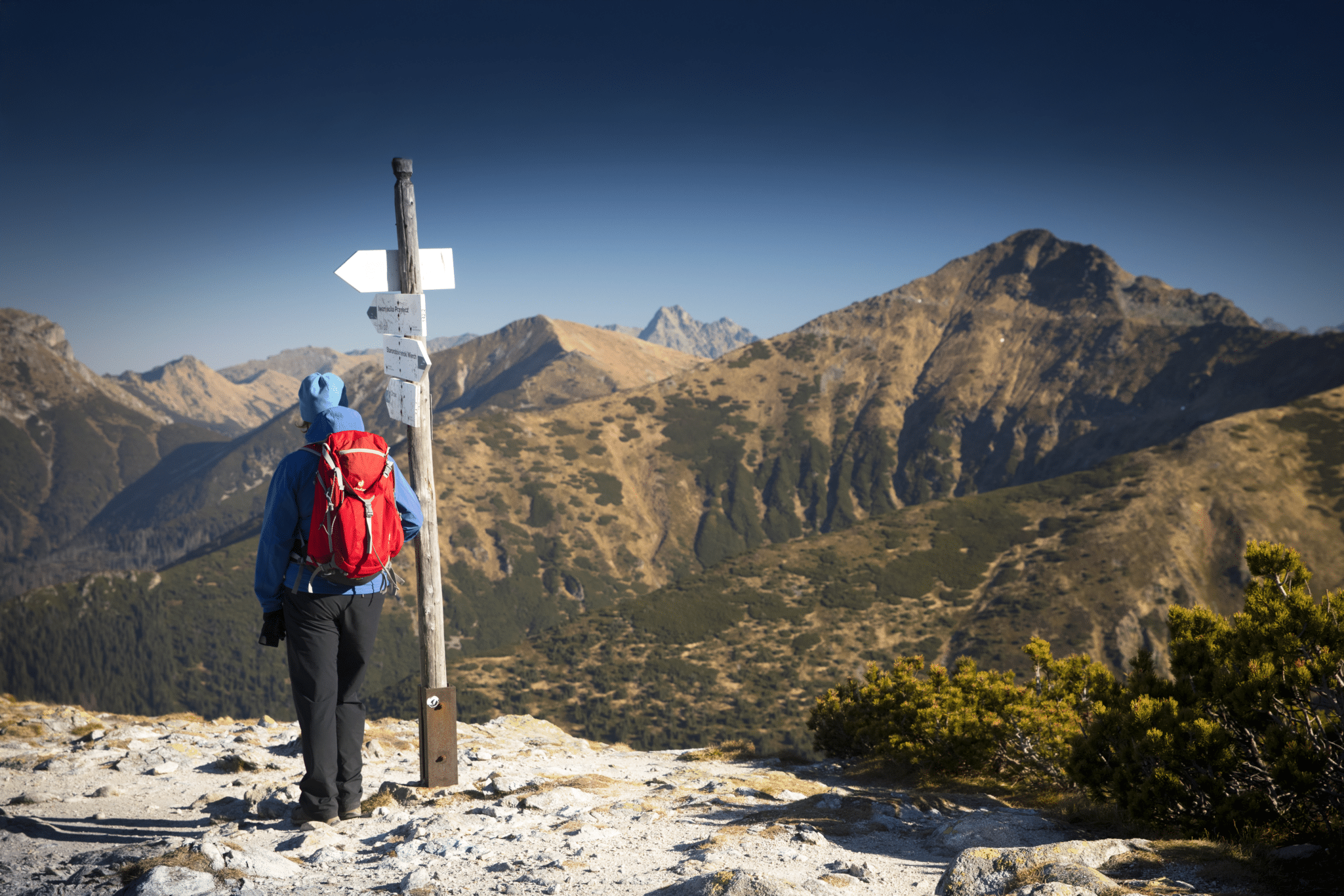
Once we got to Iwaniacka Pass, we turned left and followed GREEN trail signposted to Ornak. The path was still steep, it also got very narrow in places – due to overgrown dwarf mountain pine. It wasn’t especially pleasant to fight with pine branches all the time, but luckily this section is short and has silver lining to it – views east, towards High Tatra range were fantastic!
Ornak ridge is made up of 4 minor peaks, the highest being 1854 masl. Walking along was fun – views in all directions were amazing! We also enjoyed sections of rocky ascent (and descent) along Ornak.
If you’re planning to hike Ornak ridge, make sure you have plenty of time to enjoy it – you’ll be shooting photographs constantly!

During our hike (full day), we met only one other couple – on Ornak. They were locals, who dropped their kids at school and ventured to the mountains for a quick hike, before picking the children up in early afternoon. We chatted a bit and found them very like-minded! It’s always a joy to meet someone while hiking and feel instant connection!
Ornak ridge finally descends to Siwa Przelecz (Siwa Pass) at 1812 masl.

Should we be sensible or … ?
At Siwa Przelecz we had to decide whether to take an ‘exit path’ along BLACK trail, down to Dolina Chocholowska (the shorter Ornak hike route) or continue further along the mountain ridge to Gaborowa Przelecz and then to Starorobocianski Wierch (2176 masl) – the highest peak in Western Tatra mountains (plus another two summits).
It was a tough decision; deciding to continue along the high mountain ridge, we faced a very long and hard hike (24 km in total). There weren’t any other paths descending to Dolina Chocholowska to take in between. Hence it was either ‘getting down now’ or ‘totally thrashing ourselves’ in the mountains and reaching the valley much later, well after dusk.
We have another 3 hours of daylight, let’s add another 3 mountains to the itinerary!
I admit, we were tempted to follow the original plan and just descend to the valley by BLACK trail from Siwa Przelecz… however, day was still young – we had another 3 hours of daylight to use. I think, what finally helped us to decide was the fact that we just couldn’t stand the thought of wasting a nice day for a return walk in the valley. Come on, we still had another 3 hours of sunshine available, why waste it for walking along Dolina Chocholowska, when we can trot along the ridge, if pushed hard we would possibly reach its end just before nightfall?! We had torches with us, therefore we would be fine to follow a flat valley, on a well made track in pitch black…
I guess you already know what we decided?

Hiking from Siwa Przelecz to Starorobocianski Wierch, Konczysty Wierch and Trzydniowianski Wierch
Before heading to Starorobocianski Wierch we had a quick chat with the local couple again. It would be very nice to continue the hike together, but unfortunately they decided to descend at Siwa Przelecz as they needed to pick up kids from school.
After a quick calculation we confirmed, we needed another 3,5 hours to reach Dolina Chocholowska, if lucky we would descend just before nightfall. Yes, you guessed right, we decided to continue the hike despite being a bit tight with time.

Having decided to ‘go for it’ and trot over another 3 mountains, we had to take it sensibly. First, we needed to get some more energy, hence we stopped at Gaborowa Przelecz for a short break and a sandwich. Then we continued along RED trail to the highest peak of a day – Starorobocianski Wierch. Views from its top were breath taking, we admired mountains on Polish and Slovak side of the border.

RED trail zig-zagged down from Starorobocianski Wierch and soon took us to the next peak – Konczysty Wierch (2002 masl).
The RED trail then continues to few more peaks of Tatry Zachodnie (Western Tatra), but at Konczysty Wierch we turned along GREEN trail, signposted to Trzydniowianski Wierch (1758 masl) – the last summit of the day. We actually felt very happy about reaching Trzydniowianski Wierch still in daylight; even more – we were then sure to descend to Dolina Chocholowska without need for torches! See, we really can push ourselves when needed!!!

There are two descend trails at Trzydniowianski Wierch, both trails are marked RED. One of them is signposted to Dolina Chocholowska and the second to Polana Trzydniowka.
The first option is a bit longer, but gentler – it ends at the mountain hut at Polana Chocholowska before continuing along the Chocholowska valley back to the bus stop in Witow.
We took the other trail (Polana Trzydniowka), which turned out very tiring – roots of dwarfed pines were sticking out high over the ground, the path was also very steep in places. We chose this trail due to time constrains, however it was a really frustrating end to an amazing hike. We actually had to shout swear words from time to time, to keep us motivated. Do you also find swearing help you to keep going????

A very happy and unexpected ending to a great hike
Surprisingly, we managed to reach the Chocholowska Valley just before 16.00 hours, in the last rays of sunshine!
Final section of descend, just before the valley, was a mess. Couple of months earlier, there was a very bad storm that resulted in hundreds of fallen trees in Koscieliska and Chocholowska valleys. Works on securing the trees and clearing trails still continued, hence lower mountains and valleys were full of busy lumberjacks and heavy machinery.
Then we spotted a digger slowly rolling down towards the valley, and actually joked that the guy is running away from us – we must have been looking really exhausted haha! Indeed, he was a lumberjack just finishing his shift and moving the digger to a small, makeshift car park where his own car was parked.
A thought appeared in our minds – what if we can get a lift instead of walking another 5 km thru the valley to bus stop?
Guess what, we only managed to descend to the valley and walk few steps, when the lumberjack’s car appeared behind us! Bea didn’t think twice and she waved couple of times.
What were the chances; the guy stopped and took us – hurray! We didn’t even mind that he smoked while driving and asked us hundred of questions to check if we would potentially be future customers of his B&B business… if he only knew that last time we were in Tatra was 8 years ago and we aren’t really a ‘good catch’…

At the end of the day we were very happy to have decided to continue the ridge walk instead of descending from Siwa Przelecz. With a bit of luck we got to the bus stop in Witow just before nightfall! That was a much better ending than we could ever imagine!
Returning to Zakopane from Witow / Dolina Chocholowska
Once you’re at the bus stop in Witow, you can hitchhike or take one of many mini buses awaiting walkers returning to Zakopane.
If, however, you came by car and need to walk back to the car park in Dolina Koscieliska, follow a GREEN trail signposted ‘Droga pod Reglami’ (to your right) and continue for 3 km until you reach Dolina Koscieliska / Kiry.
Ornak, Starorobocianski Wierch and two valleys – Koscieliska and Chocholowska, hiking map

What we loved about hiking from Dolina Koscieliska to Ornak (and another 3 mountains!)
You shouldn’t have any doubts that we thoroughly enjoyed this long hike in Western Tatra! We loved it from the very beginning – Dolina Koscieliska is our favourite valley in Tatra, especially when we end up having ‘szarlotka’ at mountain hut on Hala Ornak! We absolutely loved view from Ornak ridge and the experience of hiking in this part of Tatra! The proof is in extending the ridge walk by conquering another three mountains! Despite the route being long and hard, undoubtedly we would hike it again and strongly recommend it!
How to shorten hike to Ornak in Tatra
As we mentioned in the introduction, the post mainly focused on the long, challenging route via Ornak. Please read below for a shorter and easier option.
The shorter route also begins at Dolina Koscieliska and follows the same trails till Ornak ridge. However, instead of climbing additional 3 peaks, you can descent to Dolina Chocholowska directly from Siwa Przelecz, just past Ornak. Take BLACK trail down to the valley, approximate descend time 1.5 hours. Once in Chocholowska valley, continue along GREEN trail to bus stop in Witow.
Alternative hikes in Koscieliska and Chocholowska valleys
Alternative short hike – option 1 – walking from Dolina Koscieliska to Dolina Chocholowska via Iwaniacka Przelecz
If you’re after a shorter, relaxed walk in Tatra valleys, why not hike along Dolina Koscieliska to mountain hut at Hala Ornak, and then cross to Dolina Chocholowska via Iwaniacka Przelecz? This route includes only one steep ascent (to Iwaniacka mountain pass), ascent time from Hala Ornak to the pass approximately 1 hour.
Alternative long hike – option 2 – walking from Dolina Chocholowska to Trzydniowianski Wierch, Starorobocianski Wierch, Ornak, Iwaniacka Przelecz, descend to Dolina Chocholowska
You could also make a circular hike from Dolina Chocholowska. Follow the valley till mountain hut, then take RED trail to Trzydniowianski Wierch and continue over Starorobocianski Wierch to Ornak and down to Iwaniacka Przelecz; then take YELLOW trail back to Dolina Chocholowska. This route however, will make a long and hard day in the mountains, distance approximately 23-24 km.
LOOKING FOR OTHER AMAZING HIKES IN TATRA MOUNTAINS? CHECK OUT THESE TRAILS!
If you’re looking for other hiking ideas in Polish Tatra mountains, from Zakopane, check out these amazing walks! All include detailed route descriptions and hiking maps:
CZERWONE WIERCHY – iconic ridge walk in Western Tatra over the ‘Red Peaks’, includes visiting Dolina Koscieliska (Koscieliska valley) for the best Tatran szarlotka (apple pie)
GIEWONT AND KASPROWY WIERCH – amazing day hike to two most iconic peaks in Western Tatra
FROM MORSKIE OKO TO DOLINA 5 STAWOW VIA SZPIGLASOWA PRZELECZ – a long and challenging hike thru some of most spectacular scenery in High Tatra range
HIKING FROM HUT TO HUT IN TATRA NATIONAL PARK – a fine 6 day adventure! The route starts from Dolina Chocholowska and ends in Palenica Bialczanska at the eastern end of the national park. Along the way, you’ll pass some of the most iconic Tatra peaks and passes, as well as beautiful valleys!
Not sure what to expect? Or maybe you’re looking for more information on recommended experiences and walks? Check out our detailed guide to Zakopane and hiking in Tatra mountains! We listed 12 best hikes (detailed route descriptions and maps!), handy tips on local culture and cuisine, how to get around smart… We’re also sharing insider info on how to have the best experience while visiting Zakopane, Tatra National Park and Podhale region. Our guide provides all the information you need to enjoy your visit in Zakopane, and fall in love in Tatra mountains!
Finding accommodation in Zakopane
You will be pleased to know that we thought about everything to make your visit in Zakopane nice and easy, hence it won’t come as a surprise that we even hand picked some fine accommodation options for you!
Head to Where to stay in Zakopane, our top 10 picks for ready, preselected accommodation for you. Booking your stay in Zakopane has never been easier!
*Level of difficulty explained: 1– easy walk, mostly flat 2-easy hillwalk, good path 3-moderate, possible some steep sections 4-long hillwalk, possibly some scrambling involved, possibly pathless 5-difficult, possibly pathless, long, requires technical skills
