
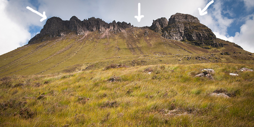
Stac Pollaidh (also known as Stac Polly) is possibly the best known mountain in Coigach and Assynt Scotland. It is a very popular hiking destination, and for all good reasons! Stac Polly has a lot of character – its distinctive, rocky ridge can be seen from many miles around, it also makes a great ‘half day’ walk. The mountain has two summits connected by rocky ridge- most walkers finish their hike by reaching the summit ridge only, or climb to eastern summit – easier of the two. Climbing to western summit, however, can prove challenging – it involves scrambling to an exposed high ridge and passing ‘the bad step’, it requires good head for heights and ‘hand on rock’ skills.
When we think about North West Scotland there are some places that come to mind instantly- Stac Pollaidh is one of them. We have visited this little mountain several times, but anytime we are in Assynt and see its distinctive silhouette in the distance we’re always excited to re-visit.
In this post we will focus on a hike to the summit ridge as this can be enjoyed by more hikers (difficulty rating 2/5*), however I will also mention how to conquer eastern (easier) and western summit (hard, requires good head for heights and ‘hand on rock’ skills hence difficulty rating 4/5*).
Stac Pollaidh in Assynt Scotland, fact sheet

- Height: 510 masl
- Total time: 3-4 hours
- Total distance: 4.5 km
- Parking: dedicated car park along small single track road to Achiltibuie. Click here for directions.
- Level of difficulty: 2-easy hillwalk, good path (summit ridge and eastern summit), 4– scrambling involved, exposed sections (western summit)
- Stac Pollaidh weather: click here to check weather forecast for Stac Pollaidh
- Which map: OS Explorer 439 Coigach and Summer Isles (click here to buy)
Parking at Stac Pollaidh
Hike to Stac Polly starts at the dedicated car park. This car park tends to be busy from lunch time onwards – in the summer we recommend hiking Stac Pollaidh either early in the morning or in the afternoon. Otherwise the car park might be tightly packed with cars and campervans. Although there is another small parking bay available, one can struggle to find a parking space when arriving mid-day. Parking at passing places is forbidden, please leave your car in designated places only.
Stac Pollaidh hiking trail
Hiking trail to Stac Pollaidh starts at the opposite side of the road from car park. One only has to pass the gate and the adventure begins! At first the path is made into stone steps built of large boulders. It winds thru woodland, low bushes and high heather. Heather in Assynt Scotland tends to be overgrown, therefore path seems narrow.
We gained height very quickly, it’s a very good warm-up! Soon path came to a fence and a kissing gate. We continued right at the fork – we recommend following the right fork simply because it’s a better path and offers better views. The other path can be used as a return route, however it’s a bit wet and not as enjoyable.

All the way up path is well made and easy to follow. It passes eastern end of Stac Polly, comes to an open ground and flattens a bit. It’s a fantastic spot to take pictures – always a good excuse for a breather! The views are amazing – right behind is the largest loch in the area (Loch Lurgainn) and several higher summits – best known Ben More Coigach. We’re always astonished by this view, it brings memories of an adventure when we wild camped at it’s narrow summit ridge.
As trail rounds along eastern side of Stac Pollaidh, it slightly steepens and soon turns into stone steps. Again, it’s a fantastic spot for a short photo break as views open in all directions. Now, the dominant mountains are Cul Mor (to the right) and Suilven (ahead) as well as lochs of Inverpolly Forest area. There used to be a forest in the past, hence the name, however now this is a rugged, flat-ish ground with hundreds of lochs and lochans (very small lakes). Indeed, it looks flat, but once we explored Assynt Scotland by foot we realised that it’s far from flat!
Grey bare rock sticking out of the green and yellow, soft – almost ‘plushy’ grass, looked unreal. These lush greens, crystal lochs and grey rugged rocks are characteristic to Assynt Scotland, as well as wild monolith mountains. They make an astonishing impression, out of this world!

Final stretch of trail leading to the summit ridge is steep, but stone steps make it easy. If, however, anyone finds it challenging, we recommend taking it easy, climb slowly and have breaks. Reaching the summit ridge is definitely worth the effort! So take your time, enjoy the views and continue up! Last several yards are steeper still, but the summit ridge is already within reach so no need to hurry, take care, you’ll be there in no time!
Stac Polly summit ridge
The trail meets summit ridge at a small saddle, it’s a final point for many hikers. Views are magnificent in all directions! The saddle is relatively spacious, a great resting point! As everyone feels elated when finally reaching the ridge, it’s easy to chat with fellow walkers, exchange thoughts, or simply share the experience. The ridge, however, tends to be windy, so it’s a good idea to find a sheltered spot for your tea and sandwich break.
Stac Pollaidh eastern (easier) summit
Many hikers venture to climb the eastern summit – it definitely is easier than the real, western top. In fact, it’s only a short and easy scramble to eastern top and we definitely encourage everyone to give it a go! There is a faint path on the left side of the rocks. For those who don’t fancy getting their hands on the rock I would still recommend exploring the ridge itself- it’s not exposed and has a path along. Having a look at what lies further gives a really good feel of this little mountain!

Stac Polly western, ‘the real’ summit
For adrenaline seekers we recommend having a look at western summit. Let me put it straight – it requires a good head for heights, confidence and scrambling skills, but is not as scary as one could imagine. To reach the true summit you’ll first have to find a suitable access point to the high, rocky ridge. It can be tricky. From our own experience we know that there are numerous gullies or ravines which look suitable at first, but prove to be a bad choice higher up; we had to scramble down on couple of occasions and try another way. What is more, once we tried to tackle the western summit, but not only failed to identify a good ‘access gully’, also had to give up due to strong winds. This is another, very important factor which has to be considered when tackling the western summit. Wind at Stac Pollaidh can be merciless and greatly add to the challenge factor. So, please, take care out there!

On our last visit Bea managed to find a good access point to the higher ridge. She walked along the lower summit ridge (the one which is reached by trail from car park) to the very end. She passed two decent looking gullies to the right and continued ahead until very end of path. By the way, the photograph above portrays Bea at the top of a ‘decent looking’ gully, one we had to scramble back down. We managed to find a decent route up in the next gully. We had to climb loose rocks (not very steep) till about 2/3 height and there was a narrow path along the ledge, to the left. We followed it further, over a serious looking drop, around the corner. The path reached a small ravine which we climbed straight up, reaching the higher summit ridge relatively easy.

Oh, we felt so happy! Do you know the feeling of being at the top of the world? Yeah, Stac Pollaidh definitely can provide that! To our surprise, on the very top of ridge was a clear path leading straight towards the western summit! It was easy to follow until the crux (bad step), just before the summit.
So what about the crux? It’s a tricky section where you’ll have to step over high drop, there is very little handhold and it’s more than one step to be made. I admit, at this point I felt overwhelmed and decided not to proceed further. That was right below the summit thou. Should we pass the ‘bad step’, reaching western summit would be easy, only a short scramble.
Luckily, we made a point to remember where exactly access gully to the higher ridge was, so we could return the same way. Summit ridge is exposed and loosing our way could be dangerous. We would be put into stressful situation if we started descending more difficult way, or one which requires rock climbing skills.

Return to the car park
There are two ways of returning to the car park – either retracing your steps along eastern side of Stac Pollaidh, or alternatively descending from summit ridge to the right, along the fence, and then round western slopes of Stac Polly. This path follows flat-ish, boggy grounds and finally meets the original path at the kissing gate.

Stac Pollaidh hiking map

Wild camping and nearest campsite information
Assynt is one of the most remote and wild areas of Scotland, its wast open spaces are sparsely populated. Hence, finding a spot to wild camp in Assynt is easy. There are many car parks suitable for overnight stay (in a camper), alternatively one can find a good spot to pitch a tent with ease. Scotland’s access legislation (the Land Reform Scotland Act 2003), states that wild camping is allowed on most unenclosed land, apart from specially managed areas (like Loch Lomond and Trossachs National Park). The tent should ideally be invisible from the road or nearest dwellings. Stac Pollaidh dedicated car park is actually a very good spot to spend the night, if necessary. We can also recommend a small, quiet spot over Achnahaird beach, however it’s another 20 mins drive along single track road from Stac Pollaidh (directions)
There are only a couple of campsites in Assynt, all picturesquely located near the sea. The best ones are: Ardmair campsite (nearest to Ullapool), Achmelvich beach – Shore Caravan site (special recommendation due to location at one of Assynt’s best beaches), Clachtoll Beach campsite (also recommended), Scourie Caravan Park (located farthest north).
What we loved about hiking Stac Pollaidh
Stac Pollaidh is a fantastic viewpoint to lochs and summits of Coigach (south), Inverpolly Forest and monolith mountains of Assynt Scotland (north). It’s an easy hike with well made paths. This small mountain is attractive to all hikers: beginners will find it easy to hike to summit ridge and eastern summit, experienced hikers and confident scramblers will love the challenge of conquering the western summit.
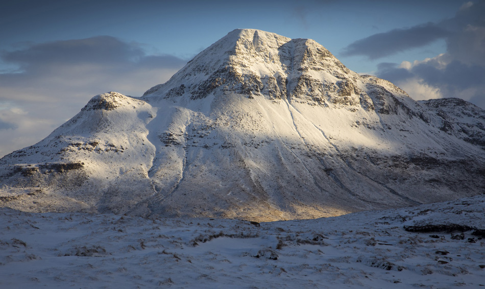
Would you like to conquer Stac Pollaidh in winter, but are unsure how to prepare for the challenge?
Read our article on Winter Hiking Tips to find out what to expect during a wintry hike and how to prepare for one, so you can comfortably and safety enjoy the stunning wintry outdoors!
Check out the wintry photographs below and find out what it’s like to hike Stac Pollaidh in snow!


*Level of difficulty explained: 1– easy walk, mostly flat 2-easy hillwalk, good path 3-moderate, possible some steep sections 4-long hillwalk, possibly some scrambling involved, possibly pathless 5-difficult, possibly pathless, long, requires technical skills
