
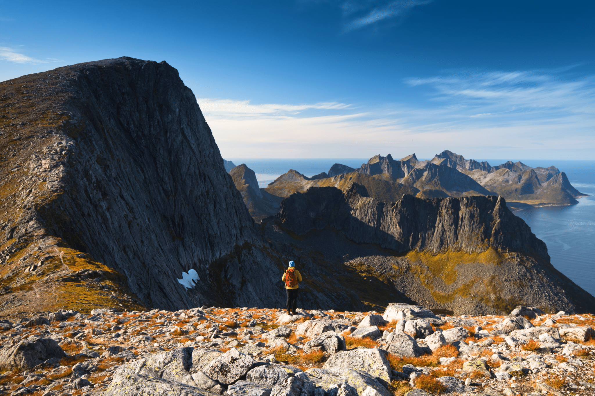

Keipen and Grytetippen are two majestic peaks on Senja island in Northern Norway. They’re located at two ends of a rocky ridge hence most often visited together, during one hike. There are two ascent paths to Keipen and Grytetippen, both graded as ‘challenging’. Hike to Keipen Senja is a fantastic day out, and the views along the way are simply mind-blowing!
In this post we will focus on approach from parking bay along road 862.
Hiking to Grytetippen and Keipen on Senja island in Norway, fact sheet

- Height: Keipen 938 masl, Grytetippen 885 masl
- Total time: 7 hours
- Total distance: 6 km
- Parking: parking bay along road 862, fitting 5 cars (directions)
- Level of difficulty: 3-4/5 -strenuous hill walk, steep climb to the summit ridge. Norwegian standards: RED – demanding.
- Keipen and Grytetippen weather: weather forecast for Grytetippen
‘Viking Blood’, as we called the Norwegian guy met on Hesten the other day, recommended hiking to Keipen Senja and Grytetippen. Paraphrasing his words ‘Segla mountain is fine, but Keipen is belissimo & has a wow factor’. He was not a stranger to Senja’s mountains and we confirm – he was right. If you are looking for a secluded, challenging hike with breath taking views across the island this is a perfect hike for you!
Norway once again tested our determination – it rained for two days after we hiked Segla and the clouds were very low all the time. The decided to wait until the weather improved and have a break from a camper. We booked Airbnb accommodation, caught up with admin work, simply enjoyed nice and warm apartment just watching the rain through the window and fascinating northern lights at night, from a terrace!
Fast forward 2 days, we were on our way to the trail head of Keipen Senja.
It was a nice chilly morning, locals were preparing for winter already – we passed a truck fixing snow polls on the roadside. Our Airbnb host mentioned that the snow may come any day now. However, this morning we enjoyed fantastic sunshine, winter and snow seemed to be months away…

How to get to Keipen and Grytetippen trailhead
You can hike to Keipen and Grytetippen by two trails. Both are similar level of difficulty and length, however only one of them is signposted. The second is a bit ticker to find but with instructions from our Airbnb host we managed to find it without too much hassle.
Option 1: Car park along road number 275 at Mefjordbotneidet (direction to Fjordgard), just before a tunnel, on the right hand side (directions). Trail is marked to Barden and Daven, once on the ridge, turn right and follow a faint, steep path. At the plateau with lake, join main Keipen path, marked.
Option 2: Parking bay at road number 862, mid-way along lake Mefjordvatnan (directions). From the bay walk 100 metres to the left, pass small stream and you’ll find a ‘Keipen and Grytetippen’ signpost. Follow marked path to the summits.

Hiking to Keipen and Grytetippen on Senja
After recommendations from a local, we decided to take the trail leaving a small parking bay at lake Mefjordvatnan. We also think that this route is a little bit easier than trail thru Daven.
Having left the parking bay, we followed main road for about 100 metres (towards Fjordgard) and looked for a small stream. Once we passed the stream we saw a signpost for Keipen and Grytetippen, but we also expected to see a path… What we saw, however, was a trodden grass and a swamp. That was the trail, thou!

The initial ascent of 450 meters is a bit of struggle, or at least it was in early September after 2 days of rain. It was very wet and we had to focus on staying dry-footed, not allowing the water inside our boots! The trail, albeit bad quality, was easy to follow as it ran almost parallel to the stream. Some 45 minutes into the hike, you leave the wet grassland and the path turns to the left. From that point the trail becomes very well defined and drier. You’ll pass the boulders first and then come to a grassy plateau.

From the plateau you can enjoy views towards Breidtinden (Senja’s highest mountain) and Mefjordvatnan, you will also get first glimpse of Keipen and Grytetippen. The two peaks will be towering high above you; seizing their steep rugged slopes you’ll try to spot the trail, but fail. Don’t worry, although the path is not visible from the plateau, there is one, trust us!

The path then briefly descents from the plateau, but soon takes you to the foot of Grytetippen; before your eyes is the rugged saddle between our two peaks.
You will now climb the steepest section of the hike, to the saddle. The trail runs along slope of Grytetippen, thru combination of big boulders and scree, it is also eroded in places hence definitely more attention is required! It isn’t as steep as it seemed from the plateau, and although you couldn’t spot the path from below, now you’ll notice it’s actually there and clearly visible.

To continue the hike, follow red marks on the rocks, keep in mind that you are not aiming for a top to your left but to the saddle – the lowest point on the ridge between Keipen and Grytetippen. It’s always easier to spot the path when you roughly know where you’re heading.

Once on the ridge, you will find yourself between the two mighty peaks of Senja. Unfortunately, climbing both of them involves returning the same way to the saddle, and then retracing your steps to the car park, later on.
Of course you can choose which peak to climb first, Keipen or Grytetippen, however we recommend to continue to Keipen first. Looking from the ridge, Keipen looks still quite a distance away, but to be honest, reaching its top came easier than we anticipated.

The ridge is a great viewpoint, take time to admire sights to the other side.
I bet you did not expect this! To see the abyss is an emotional experience and even someone who doesn’t have a good head for heights can enjoy and appreciate it. Nonetheless, Grytetippen’s rock face is impressive! Luckily, ridge is wide enough to feel comfortable and keep a good distance from the edge.

OK, let’s continue the hike!
From the saddle continue to the right – it is a steady 20-30 minutes climb to the top of Keipen. The summit is marked with the largest cairn on Senja, so you will know exactly where to head. In a good weather, the 360° panoramic views from Keipen are amongst the best you can experience in Norway! Rocky mountains raising from the fjords and cool blue waters of an open ocean on the horizon. Amazing! We were so happy to reach the top, that we literally were running from one viewpoint to another one – taking dozens of pictures and absorbing the views as much as possible!
Have a look at the photos from Keipen’s top!


At Keipen’s summit we had a well deserved lunch, another way to postponing the descent as much as possible. We were awed by the views, but at the same time eager to find out what Grytetippen has to offer. The only think which finally kept us moving was the thought of climbing the neighbouring peak. Therefore we retraced our steps along the ridge to the foot of Grytetippen, only to face another steep climb to the summit.

If you decide to hike Keipen, do not skip Grytetippen!
It’s a majestic mountain and the views from its top are incredible as well, if not even more spectacular than from Keipen. It is hard to compare both of them thou. At 938 masl, Keipen provides fantastic and jaw dropping views all around the whole of Senja. It is a overwhelming experience. Grytetippen however, is the spiky point over the fjords and its top offers incredible view to Fjordgard area and blue waters of Ornfjorden and Oyfjorden. I admit, sights from this summit totally gripped my heart and never let go. Just out of this world!
OK, let’s now have a look at photographs from Grytetippen’s top!


Having reached the second summit of the day, we were over the moon! We were both so impressed with Senja’s vistas, fjords and panoramas, our souls screaming of joy and happiness! We simply loved it, especially the view to the rock wall of Keipan, right in front of us! Looking at the narrow mountainous peninsula with Fjordgard and Segla, we felt at the roof of the most amazing world! World, which we were proud to be a part of, world worth preserving and taking care of.

After about an hour on Grytetippen, we put our names in the ‘guest book (look for our names under 5/9/18). We were in no hurry to come back, but as the evening was approaching, we were forced to slowly retrace our steps to the saddle and further to the parking bay. One final look at the heaven in front of us and we were on our way down…
Keipen and Grytetippen hiking map

Camping near Keipen and Grytetippen
Unfortunately, there aren’t many campsites in northern and western Senja. The only one in the area is Fjordbotn Camping (website) located in Indergard, 15 km away from Fjordgard.
Wild camping is allowed and widely accepted in Norway. By law, everyone is allowed to stay overnight at any spot at least 150 metres from nearby buildings.
Trail to Keipen and Grytetippen offers some fantastic wild camping spots; the best locations are plateau under Grytetippen and grassy slopes near Daven. Both Keipen and Grytetippen summits are rocky and not suitable for pitching a tent.
Alternatively, at the end of the road in Fjordgard is Purkenesvika – an idyllic outdoor area with benches, barbecue hut and a toilet. There is also space for few tents and a couple of cars or caravans. It’s a fantastic place to ‘stay wild’ while visiting Fjordgard (in exchange for a donation), but please be respectful. Local community is amazing, generous and very welcoming. They look after Purkenesvika and visit it on regular basis. Purkenesvika is also perfect for fishing, but you need to have your own fishing rod (fishing in ‘open waters’ is allowed without licence). Drinking water can be filled up at the village shop (hose with fresh water is fixed at the shop left side).
We stayed at Purkenesvika for about a week in total, by far it was the best local community experience in Norway. During the stay, we saw elders coming for their daily walk to the beach, parents with kids enjoying the Sunday sunshine. As ‘wild campers’ we were greeted and treated very friendly. What was even more amazing, local school allowed hikers to use their facilities (toilet and shower!) when the kids were out. I really wanted to mention this, because it touched me to see such responsible and generous community. You know, the trails near Fjordgard were the cleanest ever, we didn’t see any rubbish, toilet paper nor ‘human waste’ at all. And I believe this was mostly due to the fact, that local community recognised the increasing need for ‘tourist infrastructure’, and, as there’s none, they allowed to use school’s facilities and Purkenesvika.
Majority of visitors at Fjordgard were respectful, but with time we noticed that some campers used the toilet to leave their rubbish… because they didn’t bother to walk 100 metres to the large rubbish container provided. What a shame!
Please note that there is a large rubbish container along the road between Purkenesvika and Fjordgard village. DO NOT LEAVE YOUR RUBBISH IN THE TOILET! Do not expect anyone to clean after you! If you’re not a respectful guest, the local generosity may end… that would really be a shame.
Staying at Purkenesvika was a pleasure, a real highlight of our Norwegian adventure. We both left a piece of our hearts at the road end in Fjordgard… on the day we left Fjordgard for good, we shed some tears…
Update July 2019 – Purkenesvika parking area had temporarily been used by tunnel maintenance crew to store heavy machinery while they’re working on Fjordgard tunnel upgrade. Hence this area may be temporarily unsuitable for camping in summer 2019. In this case you can try the two parking areas at the entrance to first Fjordgard tunnel from main road no 862 (directions) where the machinery was previously kept.
What we loved about hike to Keipen and Grytetippen
In one word – the views. All the way up they were spectacular. Whether admiring the mountains around, blue fjords or bare rock cliffs – the view will leave you in awe for a long, long time. If you ever wonder which mountains to choose on your visit to Senja, rest assured that Keipen and Grytetippen are the ones to include on your ‘to hike’ list!
LOOKING FOR OTHER AMAZING HIKES ON SENJA?
If you’re looking for other hiking ideas on Senja island, check out these amazing walks! All include detailed route descriptions and hiking maps:
BARDEN – located near Fjordgard, is locals’ favourite hike. The trail follows a mountain ridge directly over two beautiful fjords.
SEGLA AND HESTEN – enjoy Senja’s most iconic views and climb Fjordgard’s gems! Climb steep slopes of Segla for incredible view to Mefjorden and surrounding hills, or conquer Hesten to admire Segla’s sheer, vertical rock cliffs… or why not go for an ultimate experience and climb them both?!
HUSFJELLET – an easy hike to Husfjell, iconic mountain over beautiful Bergsfjorden, Senja’s only fjord dotted with dozen of small islands. Hiking for sunset or midnight sun highly recommended!
*Level of difficulty explained: 1– easy walk, mostly flat 2-easy hillwalk, good path 3-moderate, possible some steep sections 4-long hillwalk, possibly some scrambling involved, possibly pathless 5-difficult, possibly pathless, long, requires technical skills
NORWEGIAN DIFFICULTY LEVEL EXPLAINED: GREEN – easy , BLUE -moderate, RED – demanding, BLACK -expert

Great post with some amazing photos of mesmerizing views. There are so many stunning hikes in Norway! I just got a new one on my bucketlist.