
Who hasn’t dreamed about conquering Carrantuohill, the iconic highest mountain in Ireland?! Located in southern part of the country (Co Kerry), off the famous Ring of Kerry road, this mountain is situated in the very heart of Ireland’s most spectacular scenery. Being a part of MacGillycuddy’s Reeks range it offers an ultimate hillwalking experience, it just doesn’t get any better anywhere else in Ireland. Saying that, it also has a bad reputation for being very moody with ever changing weather conditions which put in danger (and actually taken) many lives. Carrauntoohil Ireland is not to be underestimated nor taken lightly by any means, but at the same time it offers unforgettable experience to a cautious and experienced walker. Beginner hikers can join a guided walk (check online or simply ask at Cronin’s Yard at your arrival- there was an in-house guide when we visited in 2016)
Carrauntoohil via Devil’s Ladder and Brother O’Shea Path

- Height: 1038 masl
- Total time: 7 hours
- Total distance: 12 km
- Parking: Cronin’s Yard car park (pay and display), just before Caltramore (signposted for Carrauntoohil from N72 onwards), 45 mins drive from Killarney (small roads). Click here for directions.
- Level of difficulty: 4 – strenuous, steep ascent via Devil’s Ladder and descent via Brother O’Shea Path
- Carrauntoohil weather: click here to check Carrauntoohil weather forecast
- Which map: OSI MacGillycuddy’s Reeks & Killarney National Park 1:25000 (click to buy)
After many days of exploring Irish west coast we finally arrived to Co Kerry. Our top highlight in this area was hiking Ireland’s highest mountain, Carrauntoohil. We were not very lucky with the weather thou; first two days we spent in Killarney area were very windy. Only on the very last day of our stay in Killarney the forecast improved and we started feeling hopeful again.
Having done a lot of research on this mountain we decided on the route starting from Cronin’s Yard (there is another starting point nearby, Lisleibane), taking us up to the summit via Devil’s Ladder and back via Brother O’Shea Path.
Cronin’s Yard is a private car park and parking charge applies (2EUR in 2016) however it is referred to as a ‘donation’ (to be made in cafe). We didn’t see anyone enforcing this payment, but having parked on somebody’s private land it is only fair to respect their request and ‘donate’.

Carrauntoohil hike
There is a well signposted path leading from Cronin’s Yard towards the mountains. At first it runs between small fields and meadows which are home to very friendly donkeys. There is no question of where to go, everything is very straight forward and path very easy to follow. The only downside is the long-ish approach to Carrauntoohil, views don’t change much for first hour.
Soon enough we arrived to a small bridge over a stream -our path merged with Lisleibane leg. After another kilometre we reached small lake, and the path forked. We passed a cairn (small pile of stones) marking turn into Brother O’Shea Path, but we ignored it and continued straight ahead, towards Devil’s Ladder.


This section used to be boggy and very wet, however it has now been greatly improved and a new trail built (in 2016). The Devil’s Ladder occupied our thoughts as it was ahead of us, in plain view. Again, we read some scary stories about this trail. In reality it is just a gully, it looked less steep with every step we made towards it.
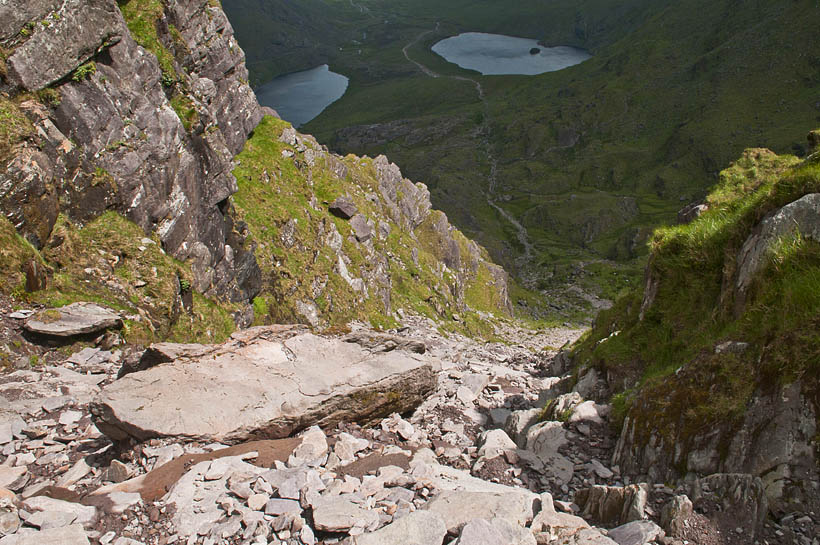
There were loose rocks and large boulders, however they weren’t too much of an obstacle and we found it much easier to climb Devil’s Ladder than anticipated. The zig-zaging path is easy to follow, steepens towards the end, but only over a short section. Saying that, please remember that care is always required.
Devil’s Ladder ended suddenly and we found ourselves on the wide grassy ridge, directly below Carrantuohill summit.

There are numerous paths leading to the summit, all of them very similar quality (loose stones) and easy to follow. Each of us picked different one, but we reached the summit at the same time. I guess it would be trickier in bad weather conditions or mist, but on a sunny day it’s a no-brainer, just pick a path at random and climb up. Summit of Carrautoohil was easily reached within 20 minutes.

At the summit a ‘reassuring’ sign ‘Turn Back Now, No Descent Route’ greeted us! Ok, that’s one thing clear, but we didn’t intend to descent via cliffs anyway! Carrauntoohil summit is marked with a tall cross and a memorial board for D.Connoly.
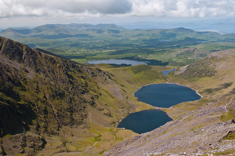
Couple of words about the summit – the views are fantastic in all directions. On a good day views stretch to the beaches of the Inch and Dingle peninsula. Amazing! All mountains around looked mighty and just as high, very impressive. Wet couldn’t imagine a better place to rest awhile, enjoy the scale of surrounding beauty. Unfortunately, the summit fiesta didn’t last long, the wind picked up and we felt it was time to make our way down.


Descent via Brother O’Shea Path
The descent path along western slopes of Carrauntoohil was very rough, it required great care because of its steepness and loose rocks, also proximity to the cliffs. Trail was quite easy to follow, just required care. Soon it reached the small saddle where Brother O’Shea Path began.


Similarly to Devil’s Ladder, Brother O’Shea Path is known for its steepness. Oh yes, it definitely is steep at first, actually gives a bit of that ‘what?! this is my path down?!’ feeling. But with care and good head for height it is not too difficult. Just watch your step and make sure to avoid loose rocks. The path is well defined and the inclination eased as we reached the little green lake. Oh, that green lake was amazing! No words required, be both instantly knew what to do – take off the boots and dip our tired feet in ice-cold water! We find it the best way to quickly refresh after the walk; cold water works miracles to feet.
No wonder that very soon we felt refreshed, revitalised and ready to continue the descent. Path was easy to follow, almost flat, but soon it became fainter. It is crucial at this point to start further descent in right place as there are some small cliffs ahead. To be able to descent safely, please ensure to be close to Carrauntoohil main massif, to the right. There is a faint path at the foot of rock wall, it’s the safest way. It soon turns into a wide, well made path again. In no time we arrived to a lake and joined the path to Devil’s Ladder. From there we retraced our steps towards the small bridge and Cronin’s Yard.

Last but not least…
Overall, climbing Carrauntoohil reminded us of Scottish Highlands, which we love a lot. These mountains are not very high, but very rugged and can challenge you alright; are not to be taken lightly. The conditions are ever changing and the walker needs to be prepared for all kinds of weather. After all, conditions in Co.Kerry area are directly determined by what’s blown from Atlantic Ocean.
Also, please note that we described an unguided walk, approaching from the north side. There are numerous other trails to Carrauntoohil; for instance, we met guided groups approaching from the west.
If you’re unsure or lack in confidence- just stay safe or hire a guide. Alternatively, for those who would love to explore the area, but don’t really fancy climbing a mountain there are suitable paths on lower ground. Many walkers end their journey at the lake (at the foot of Carrauntoohil). We believe it is a very good idea, enough to give a good feeling of this secluded mountain, but without great effort of climbing high up.

Carrauntoohil Ireland hiking map
What a treat! You can use this interactive hiking map to plan your venture to Carrauntoohil and navigate the route!

