
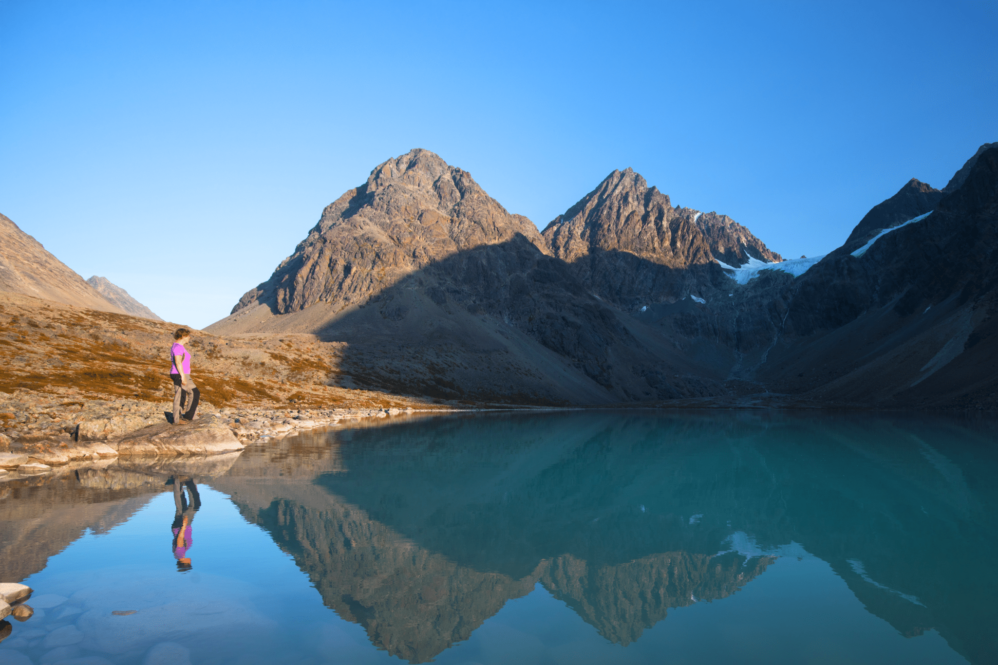
Lake Blavatnet is a true gem of Lyngen Alps in Northern Norway! Blavatnet, or Blaisvatnet as it’s sometimes referred to, means ‘blue lake’ and is a perfect description! After a short, easy hike thru Strubskardelva valley, you’ll arrive to a blue mirror reflecting rocky mountains of Lyngen Alps. A heavenly sight indeed!
The lake is easily reachable by car from Tromso. Drive thru Lyngen Alps or along Lyngen peninsula will leave you speechless, the area is simply spectacular! Continue reading to find out how to visit the amazing Blue Lake in Norway!
Hike to Blavatnet

- Height: Lake Blavatnet 180 masl
- Total time: 3 hours
- Total distance: 8,4 km
- Parking: large, marked car park just past junction of roads number 312 and 314 (directions)
- Level of difficulty: 2/5 – easy hike along rough uneven path, mostly flat (Norwegian standard GREEN – easy)
- Blavatnet weather: weather forecast for Svensby
How to get to Lake Blavatnet trailhead
Lake Blavatnet is easily accessible from nearest large town – Tromso; the drive takes about 1.5 hours, but keep in mind that it involves taking a ferry from Breivikeidet to Svensby (regular sailings). Coming to Lyngen peninsula from the south, thou, is an amazing journey, plentiful in jaw-dropping views along the way.
Hike to Blavatnet starts from a large, signposted car park (Sorlenangsbotn) along road number Fv312, less than 1 km from junction with road Fv314. Coming from the south, you’ll have it on the right hand side and can’t really miss it. Most likely it will be busy with cars already, as the lake is a very popular destination. We recommend visiting Blaisvatnet in the afternoon, for sunset. Then, the rocky mountains surrounding the lake will be glowing orange and red, a very spectacular sight indeed!

Hike to Blavatnet in Lyngen Alps
Trail to Blavatnet is marked, however most of the way you’ll struggle to see the red dots painted on boulders and stones along the way. That’s OK, don’t worry – there’s only one trail in the area.
The hike begins at the far end of car park, and first takes you thru low woodland. The man-made path is very well defined and easy to follow, although can be muddy in places. It gently gains height, but only briefly, to take you to a small ‘bump’. That’s the first viewpoint of the hike.

Sights are already fantastic, I’m tempted to say that are ones of the best (except the lake itself). Before you is a small, meandering river lazily flowing thru pine woodland. A but further you see sharp ridges of Lyngen Alps and a tongue of Lenangsbreen glacier.
Once past a small bridge over the river, the path significantly changes its character.

You’ll find that the trail keeps disappearing and reappearing, most of the time you’ll struggle to see any trail markings. However, you’ll see kind of a path; you’ll notice that some stones are more worn than others and there will be a ‘flatter’, smoother line amongst the small rocks. If you’ll loose the trail for a moment, don’t worry, just ensure to go in general direction of the glacier tongue in front of you – the lake is located in a bouldery bowl just below glacier’s tongue.

Final part of hike to Blavatnet is different in character again, as the lake is walled by large boulders. If you don’t mind a bit of scrambling and ‘boulder-hopping’ take direct approach (as we did), if however you’re after an easier route – walk further to the left and you’ll be able to reach the shores avoiding most of the large boulders.
We cut straight across the boulders to the lake and found it fun to scramble on such easy hike!

Blavatnet is simply fantastic! Looking from the road – who would think that there is such a gem hidden at the foot of majestic rocky mountains?!
When we finally arrived to the lake shores, we were speechless! The afternoon was hot and still, blue waters of Blavatnet were like mirror, reflecting high sharp ridges of Lyngen Alps. The water’s colour is related to vicinity of glacier and is simply astonishing – I would describe it as silver-blue turning into turquoise.
Despite the warm weather, water of Blaisvatnet was ice cold! It didn’t discourage two other guys from swimming in it, but it was a rather short swim!

We really enjoyed the hike and loved views over the lake, hence we took time to take in the beautiful surroundings! It’s amazing, how some places seem to be magical, encourage visitors to reflect and admire the sheer power and beauty of nature. Lake Blavatnet definitely possesses this special ambience…

One last look at the sunset lit rugged mountains and we slowly retraced our steps to the car park.
I anticipated that the way back will be a slog, but because of the warm sunset light gently caressing the rocky peaks, the way back was just as exciting as hiking to the lake!
Hike to Blavatnet map

What we loved about hiking to lake Blavatnet
I have to say that I was completely awed by the view. I also was very surprised to find such alpine scenery so far north! The hike was easy, albeit care was needed due to the uneven trail. Upon our arrival to shores of Blavatnet, we were astonished by silver-blue waters mirroring rocky peaks, already gently lit by setting sun. Therefore we recommend hiking to the lake in the afternoon, to be back at the car park just after sunset.
Wild camping near Lake Blavatnet and nearest campsite
Wild camping is allowed and widely accepted in Norway. By law, everyone is allowed to stay overnight at any spot at least 150 metres from nearby buildings. Generally speaking, in most parts of Northern Norway finding a wild camping spot is very easy, especially when travelling in a camper. Many times we stopped overnight simply along the road. It’s a bit trickier when travelling with a tent, as lower grounds are often quite rocky or wet, hence we recommend seeking wild camping spots suitable for tents at a little bit higher grounds, on along the trails.
When hiking to Lake Blavatnet, keep in mind that finding a good camping spot along the trail is tricky, as the ground is very rocky and uneven. The best place to look for good pitching ground is near the car park – there are makeshift tent pitches prepared.
Travelling with a camper, you could use either Lyngstuva car park at the top of peninsula or just stay at the Blavatnet car park – overnight stay is not forbidden.
There aren’t too many campsites in northern part of Lyngen peninsula, the nearest camping ground is located near Nordlenangen, Lyngen Fjordcamp. It’s a tiny campsite near small harbour; during our visit in September 2018, we were the only guests and the owner basically opened it just for us. The facilities are decent, with a small, warm kitchen / living room.
*Level of difficulty explained: 1– easy walk, mostly flat 2– easy hillwalk, good path 3-moderate, possible some steep sections 4-long hillwalk, possibly some scrambling involved, possibly pathless 5-difficult, possibly pathless, long, requires technical skills
NORWEGIAN DIFFICULTY LEVEL EXPLAINED: GREEN – easy , BLUE -moderate, RED – demanding, BLACK -expert
