What comes to mind when you think of Shetland? Perhaps the BBC crime drama Shetland, the charming Shetland ponies, its abundant wildlife, or the famously untamed weather.
But have you ever considered Shetland as an exciting hiking destination? This remote archipelago off Scotland’s northern coast is a paradise for walkers and nature enthusiasts alike. With nearly 1,700 miles of coastline, sweeping moorlands, and dramatic cliffs, Shetland offers a truly unique and unforgettable walking experience.
We fell in love with Shetland’s great outdoors, discovering that every trail unveils a new facet of the islands’ stunning natural beauty and rich cultural heritage. Whether you seek adventure or tranquility, Shetland is a must-visit destination.
In this article, we’ll guide you through the 10 best walks in the Shetland Islands, from gentle coastal paths to challenging all-day treks. Whether you’re drawn to the haunting ruins of ancient settlements, the vibrant wildlife that thrives in this unspoiled environment, or the breathtaking vistas at every turn, these walks promise to inspire and captivate.
From the dramatic cliffs of Eshaness to the serene shores of St. Ninian’s Isle, each route offers a unique journey through Shetland’s diverse landscapes.
So lace up your boots, embrace your sense of adventure, and join us as we explore the best of Shetland on foot. Whether you’re an experienced hiker or a casual stroller, these trails offer something for everyone—ensuring an enriching and invigorating experience in one of the UK’s most spectacular natural settings.
10 Best Walks in Shetland
1.Cliffs of Eshaness
2.Circular walk around St Ninian’s Island
3.Cliffs of Hermaness Nature Reserve, Unst
4.The Drongs view, Hillswick
5.The Hams of Muckle Roe
6.Papa Stour circular walk
7.Banna Minn and Kettla Ness
8.Sumburgh Lighthouse to Jarlshof
9.Circular walk around Isle of Noss
10.Circular walk around Mousa

1. CLIFFS OF ESHANESS
Trailhead: Eshaness Lighthouse
Distance: up to 12km (return)
Level of difficulty: easy
Attractions: lighthouse, dramatic volcanic cliffs, geos, collapsed sea caves
Wildlife: seabirds including Atlantic Puffins (colony in Calder’s geo). Good for Orca spotting.
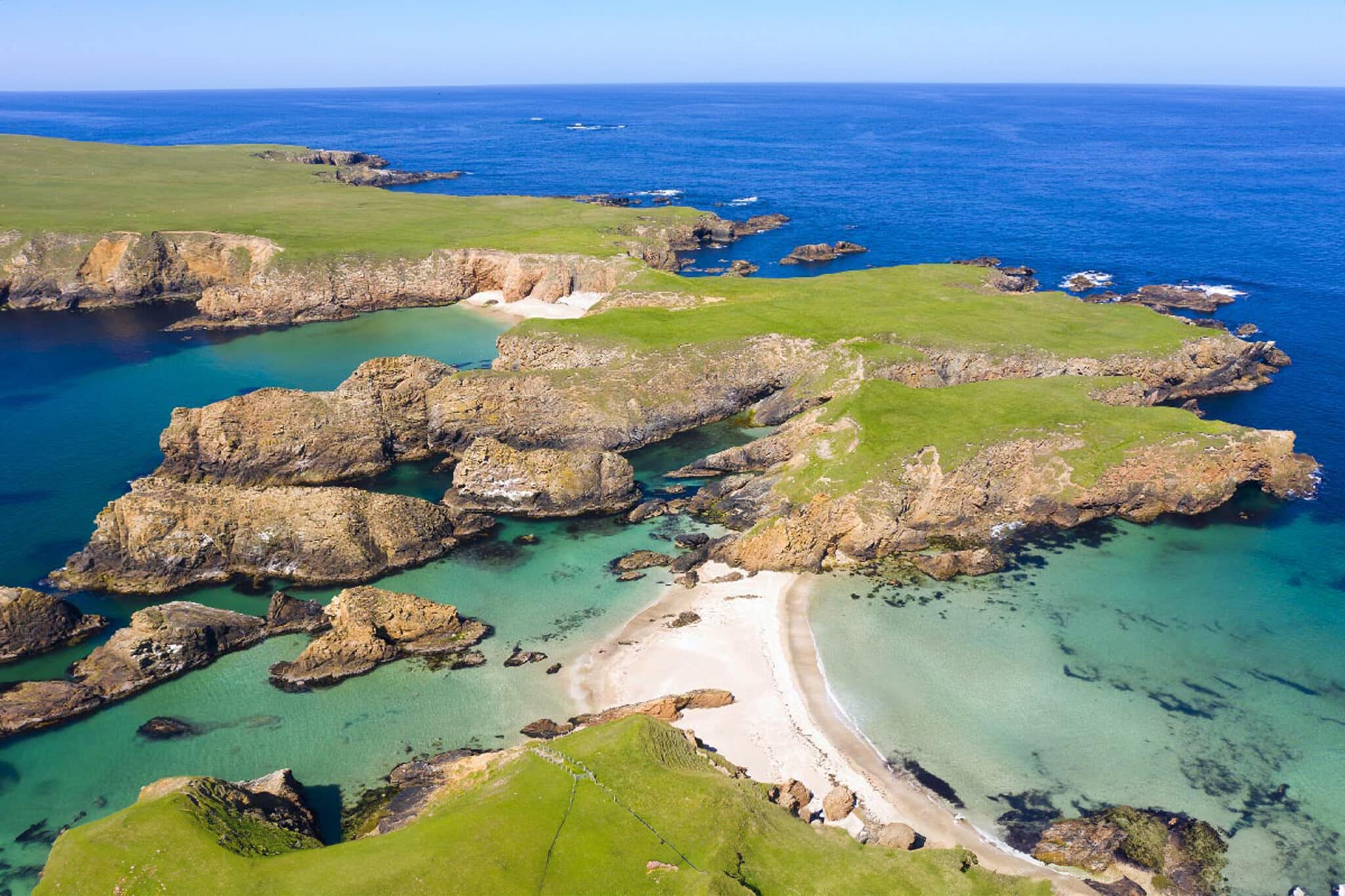
Nestled on the western shores of Northmavine, Eshaness is a rugged landscape shaped by ancient volcanic activity. Its towering, jagged cliffs provide a sanctuary for thousands of seabirds, including the charismatic Atlantic puffins that migrate here each year.
Begin your visit with a brief exploration of the coastline near Eshaness Lighthouse before returning to the car park and making your way toward the impressive Calder’s Geo. We recommend starting your hike along the northern shoreline by tracing the perimeter of the geo.
Soon, you’ll find yourself gazing out over the open sea, with the lighthouse to your left. Continue north to discover breathtaking viewpoints along the Lochs of Dridgeo. Well-trodden paths lead you to secluded bays dotted with sea stacks and islets, as well as cliffs sculpted from ancient lava flows. Be sure to keep a safe distance from the cliff edges, as some areas may be unstable due to erosion, particularly after winter storms.
As you follow the coastal path, you’ll come across a low fence with a metal gate, as well as a drystone wall. Your walk shouldn’t end here—pass through the designated walker’s gap to uncover even more striking scenery. Just ahead lie the dramatic collapsed sea caves known as the Holes of Scraada, and a short distance beyond, you’ll reach the famous Navir Grind (Grind o da Navir), a truly spectacular sight.
For your return, retrace your steps along the cliffs, with the option of a short detour to the Loch of Houlland.
If you have two cars or are hiking with a friend, you can extend the walk further along the coast to Hamna Voe, provided you’ve left a second vehicle at Ure village for the return journey. Otherwise, walking back from Hamna Voe would require a 7 km trek along the main road, which is not recommended for pedestrians.


2. CIRCULAR WALK AROUND ST. NINIAN’S ISLAND
Trailhead: St. Ninians beach, Bigton
Distance: 6km
Level of difficulty: easy
Attractions: active double tombolo, stunning sandy beach, dramatic cliffs, hidden coves, St Ninian’s Chapel
Wildlife: seabirds including some Atlantic Puffins
St Ninian’s Isle is connected to the Shetland mainland by St Ninian’s Beach—the most spectacular active tombolo in the UK.
You might be wondering: what exactly is a tombolo? Simply put, a tombolo is a narrow strip of sand or shingle that links an island to another landmass. What makes St Ninian’s tombolo truly unique is that it is actively shaped by powerful Atlantic waves from both the north and south, forming a rare double tombolo—two beaches in one.
At low tide, the tombolo reveals a broad expanse of pristine white sand, while at high tide, it narrows significantly. Depending on the weather and wave conditions, it is sometimes possible to cross to the island with dry feet even at high tide.
Most visitors admire the tombolo and beach without venturing further, but we strongly recommend exploring the entire island on foot. With its dramatic coastal landscapes—ranging from towering cliffs to hidden coves—an abundance of seabirds, and endless photography opportunities, St Ninian’s Isle is a paradise for nature lovers.
Begin your walk at the designated car park near St Ninian’s Beach, signposted from Bigton, the nearest village. Cross the tombolo and ascend the sandy dunes on the island, leaving the crowds behind. We suggest hiking clockwise, following grassy trails that lead to secluded coves with stunning views of sea stacks and islets.
For the best scenery and photography, head to the island’s northernmost and southern tips, where the views are truly breathtaking. Seabirds are most concentrated along the western cliffs, creating a spectacular sight. And, of course, don’t forget to take in the iconic double tombolo—undoubtedly the island’s main attraction.
As you near the end of your walk and make your way back to the beach, you’ll come across the ruins of St Ninian’s Chapel, dating back to the 12th century. Once an important center of early Christianity in Shetland, its weathered stone walls are now home to small birds and rabbits, adding to the island’s quiet charm.


You may also like: Hermaness National Nature Reserve
3. CLIFFS OF HERMANESS NATURE RESERVE, UNST
Trailhead: Hermaness Nature Reserve visitors car park
Distance: 13km (circular)
Level of difficulty: moderate
Attractions: world famous seabird colonies, dramatic cliffs, view to Muckle Flugga, the northernmost accessible location in the UK
Wildlife: one of Scotland’s largest colonies of Northern Gannets, several colonies of Atlantic Puffins, Great Skuas, Arctic Skuas, terns. Good for whale spotting.
Hermaness Nature Reserve is renowned for its breathtaking cliffs, but its true claim to fame is its world-class gannetry. Every spring and summer, these remote, rugged cliffs become a sanctuary for hundreds of thousands of Northern Gannets, who share their breeding grounds with Atlantic Puffins, Fulmars, Kittiwakes, Great and Arctic Skuas, and various species of terns.
To fully experience both the dramatic landscape and abundant wildlife, we recommend a circular hike that will take most of the day. The natural starting point is the nature reserve car park, where a well-maintained trail begins beside the toilet block. Pass through the metal gate and follow the signposted path.
The trail starts as a sandy incline before crossing a small burn and transitioning into a constructed wooden walkway. Following the signposts toward the cliffs, the path winds for about 1.2 km through the breeding grounds of the Great Skua (Bonxie in Shetland dialect). By this point, you’ll likely have firsthand experience with their unique nest protection strategy—diving at intruders from above. Though intimidating, these aerial attacks are meant to warn rather than harm. In contrast, terns (Tirrick in Shetland dialect) are far more aggressive defenders, attacking in shrieking groups and, in some cases, even drawing blood. While this might encourage most walkers to hurry along, I find them utterly fascinating.
Upon reaching the cliffs, follow the faint path signposted to Saito, the reserve’s largest gannetry, about 2 km away. Along the way, it’s easy to spot puffins nesting in the grassy ledges—charming, colorful sentinels of the coastline.
Saito marks the southernmost point we recommend exploring and is the highlight of Hermaness. After taking in the sheer spectacle of Gannet City, retrace your steps to the original cliffside viewpoint. From here, continue north along the coast, where sharp-eyed visitors will spot more puffins resting at the grassy edges, seemingly unfazed by the ever-present sheep.
Cross two small burns and climb uphill to another striking viewpoint overlooking natural sea arches—home to yet more gannets. Soon, your attention will be drawn to the dramatic sight of Muckle Flugga Lighthouse, perched on jagged rocks about 1.5 km out to sea.
The Muckle Flugga viewpoint marks the northernmost point of the trail. A steep ascent leads to the summit of Hermaness Hill, offering panoramic views of the lighthouse and surrounding seascape. Keep an eye out for puffins on the grassy clifftops—they allow for remarkably close observation and make excellent photo subjects.
The final stretch of the hike is a long descent from Hermaness Hill back to the car park, following the wooden walkway once more through Great Skua territory.


4. THE DRONGS VIEW, HILLSWICK
Trailhead: visitors car park at Seal Sanctuary in Hillswick
Distance: 4km (linear or circular)
Level of difficulty: easy/moderate
Attractions: picturesque cliffs, red sand beach view, close view of The Drongs seastacks
Wildlife: seabirds (mostly gulls), seals.
The Drongs are probably the most recognisable sea stacks in Shetland, however since they’re located far out in the sea, getting a good close look at them is very challenging. There are, however, remote headlands that allow getting a better view, one of them is a short walk away from Hillswick in Northmavine.
Best point to start the walk is car park at the Seal Sanctuary in Hillswick, as it’s very easy to find and offers facilities.
At first the hike crosses sheep pastures, you can expect to be closely followed by rams as they run free. Keep to the faint coastal path as much as possible and soon you’ll leave the village behind. Walking over these low cliffs is quite easy, despite a lot of short uphill sections. The two pretty islands on the right-hand side are Waterhouse and Niddister, and home to only seabirds.
Continue towards a small lighthouse as it marks the farthest point to reach. Keep clear from the unstable cliff edge and rather find a good resting spot on the grass, farther inland.
The view over St. Magnus By is magnificent, with the Drongs nearby, Muckle Roe and Papa Stour islands further away.
Look out for playful seals enjoying the bay to the left, with red sand cliffs and beach, so typical for Northmavine region.
For the return you can either retrace your steps or follow a trail along the eastern shore of headland to make the walk circular. Regardless of option, walking distance is very similar, approx. 4 km


5. THE HAMS OF MUCKLE ROE
Trailhead: visitors car park, Little Ayre
Distance: 12km (circular)
Level of difficulty: moderate/hard
Attractions: wild beaches, cute hidden coves (hams), picturesque rolling hills, remote lighthouse
Wildlife: seabirds (mostly gulls and terns), seals. Good for whale spotting
The wild island of Muckle Roe lies off Shetland’s western shores, connected to the mainland by a bridge and located not far from Brae. This circular island is crisscrossed by a network of walking trails, many of which lead to stunning coves and secluded bays—known locally as hams.
We highly recommend a scenic walk that takes in two of the island’s most beautiful and remote hams, as well as sandy beaches, rugged coastal views, and a small lighthouse, before returning to the village of Little Ayre at the southern tip of the island.
The Hams Walk
The best starting point is the visitor car park in Little Ayre. With 13 parking spaces available, it’s usually sufficient for walkers, but arriving early in the morning ensures you’ll get a spot.
Begin by following the road west, keeping an eye out for the signpost to Muckle Ayre Beach, just a short detour away. From there, the route continues along rugged low cliffs (with safety barriers and a wire fence) before reaching a small lighthouse.
Beyond this point, the hike to the hams becomes mostly pathless, but navigation is straightforward—simply follow the cliff edge as much as possible for breathtaking views of dramatic geos and crevices. Faint trails appear past Loch of Dandigeo, though they tend to fade as you go.
Upon reaching a low fence, follow it toward a wide bay—this is South Ham. The grassy dunes here are intersected by a series of low fences, but with a keen eye, you’ll find an easy way through.
Next, a gentle uphill walk brings you to North Ham, about half an hour away. Unlike South Ham, this is a smaller bay enclosed by rocky cliffs. Though more compact, it is full of character and charm. At low tide, the shoreline reveals a pebble beach and fields of fresh seaweed. Aside from the cries of seabirds, it’s a place of pure tranquility.
The Return Route
The walk back to Little Ayre car park follows a well-defined track at the bottom of a spacious glen. Along the way, keep an eye out for historic cottages and an old mill. Despite crossing two small streams, the return route is easy—though somewhat long.


6. PAPA STOUR CIRCULAR WALK
Trailhead: Papa Stour harbour
Distance: 20km (circular)
Level of difficulty: hard
Attractions: wild beaches, cute hidden coves, picturesque rolling hills, natural arches, sea stacks, collapsed sea caves, Norse Stofa, chambered cairns.
Wildlife: meadow birds (including Lapwing), seabirds (terns, gulls, single Puffins), seals, otters. Good for whale spotting.


7. BANNA MINN BEACH AND KETTLA NESS
Trailhead: Car park in Duncansclett
Distance: 7.5km (circular)
Level of difficulty: easy
Attractions: beautiful sandy beach, picturesque headland with dramatic cliffs
Wildlife: meadow birds, seabirds, seals
The best start point for Minn beach and Kettla Ness walk is visitors car park in Duncansclett, at the road end just south from Papil, West Burra. Look out for beautiful white cottages with thatched roofs before heading downhill to the beach; these are a fine example of Shetlanders’ skill to make the old and new fitting together in perfect harmony.
Embarking on a coastal walk from Banna Minn Beach around Kettle Ness promises an enchanting experience brimming with natural beauty and rugged charm. Starting at Banna Minn, a pristine beach known for its fine sands and clear waters, walkers are immediately greeted by the serene expanse of the North Atlantic. The shoreline, framed by low cliffs and interspersed with rocky outcrops, sets the stage for a captivating journey.
Exploring Kettle Ness is easy as long as you keep to the cliffs. Don’t worry about crossing drywalls, sheep have already made useful passes.
As you head south from the beach, the path meanders along the cliff tops, offering panoramic views of the sea, where waves crash rhythmically against the rocks below. The route is rich in wildlife; keen-eyed hikers might spot seals basking on the rocks and seabirds soaring overhead, their calls mingling with the sound of the surf.
Approaching the southern tip of Kettle Ness, the landscape becomes even more dramatic. The headland juts boldly into the sea, providing a spectacular vantage point. Here, the cliffs plunge steeply into the ocean, and the sight of the turbulent waters below is both humbling and exhilarating.
Continuing around Kettle Ness, the path loops back, offering fresh perspectives on the rugged coastline and its hidden coves. This walk, characterized by its raw beauty and the ever-present symphony of the sea, leaves a lasting impression, embodying the wild, unspoiled spirit of the Shetland Islands.


8. SUMBURGH HEAD TO JARLSHOF
Trailhead: visitors car park at Sumburgh Head
Distance: 4km (linnear; 7km if extended to circular walk with return to lighthouse)
Level of difficulty: easy
Attractions: lighthouse, dramatic high cliffs, opportunity (almost a guarantee!) to see Atlantic Puffins up close, unique prehistoric settlement-Jarlshof, sandy beach
Wildlife: world famous seabirds colonies, most importantly abundance of Puffins
The walk from Sumburgh Head Lighthouse to Jarlshof along the eastern cliffs of Sumburgh Head offers a journey through Shetland’s stunning coastal scenery and rich history.
Starting at Sumburgh Head Lighthouse, perched majestically atop rugged cliffs, walkers are immediately immersed in breathtaking vistas of the North Sea. The lighthouse, a beacon of maritime heritage, stands guard over the dramatic landscape, where sheer cliffs drop to the tumultuous waters below.
As you follow the well-trodden path northward, the trail hugs the cliff edge, offering panoramic views of the endless horizon and the opportunity to spot seabirds like Puffins, Guillemots, and Razorbills nesting in the crags. The scent of the sea and the sound of waves crashing against the rocks create an immersive coastal experience.
Continuing along the cliffs, the path gradually descends towards the main road and then leads to ancient site of Jarlshof, passing Gruntness harbour. Here, the landscape opens up to reveal one of Europe’s most remarkable archaeological sites. Jarlshof, with its layers of history from the Bronze Age, Iron Age, Norse, and Medieval periods, stands as a testament to human resilience and ingenuity. Extra care should be taken along the section between the harbour and Jarlshof, as the route follows a busy minor road.
You may like to extend the walk and return to Sumburgh Lighthouse along low rugged cliffs. Although an uphill walk, such hike is straight forward with well trodden paths underfoot and stiles/ladders facilitating drywall crossings.
This walk, blending natural beauty with historical intrigue, offers a unique glimpse into Shetland’s past and present. The journey from Sumburgh Head Lighthouse to Jarlshof is not just a walk, but a passage through time, enriched by the stunning coastal scenery and the whispers of ancient civilizations, together with unforgettable experience of nature!


9. CIRCULAR WALK AROUND ISLE OF NOSS
Trailhead: dedicated car park at the eastern shores of Bressay island
Distance: 4km
Level of difficulty: moderate
Attractions: dramatic cliffs, world famous gannetry
Wildlife: abundance of seabirds, with Northern Gannets, Atlantic Puffins, Fulmars Great Skuas seen up close
Setting off for a circular walk around the Isle of Noss is an immersive experience in Shetland’s untouched natural beauty and vibrant wildlife. This small island, renowned for its spectacular gannetry, offers an unforgettable journey for nature enthusiasts and avid hikers alike.
The adventure begins at Noss Sound, where a small boat transports visitors to the island (first crossing 9.00am, latest return 5.00pm) Once on Noss, the path initially leads through lush meadows and gentle slopes, setting a tranquil tone for the walk. The trail soon rises towards the cliffs that encircle the island, providing increasingly dramatic views of the North Sea.
As you approach the southern cliffs, the air fills with the cacophony of seabirds. At first you’ll spot Puffins, Fulmars and an odd Gannet, but as you continue along the ever rising path, the smell of main gannetry is unmistakable and soon you’ll arrive to the highest cliffs, home to the famous Gannets of Noss.
Noss gannetry is one of the largest in Europe. Thousands of Nortern Gannets, with their striking white plumage and distinctive black wingtips, nest on the sheer cliffs, creating a mesmerizing spectacle. Watching these elegant birds soar and dive into the sea with precision is a highlight of the walk.
The trail continues along the edge of the island, where you might spot other seabirds, along with seals basking on the rocks below. The rugged coastline, with dozens of small coves and rocky islets is a photographer’s paradise, offering endless opportunities to capture the island’s raw beauty.
Turning inland, the path meanders through the island’s rolling hills and heather-covered moors much loved by Great Skuas, eventually looping back to the starting point. Throughout the walk, the sense of isolation and tranquility is profound, making the Isle of Noss a perfect escape from the hustle and bustle of Lerwick.
This circular walk not only showcases the breathtaking landscapes and diverse wildlife of Noss but also offers a deep sense of connection to the natural world, leaving visitors with lasting memories of Shetland’s wild and pristine charm.


10. CIRCULAR WALK AROUND ISLE OF MOUSSA
Trailhead: dedicated car park in Leebitton
Distance: 3.5km
Level of difficulty: easy
Attractions: the best preserved prehistoric Broch in Europe, abundance of wildlife
Wildlife: seabirds, including terns and several kinds of gulls, seals, good for whale spotting
Embarking on a circular walk around the Isle of Mousa offers a unique opportunity to immerse yourself in the untamed beauty and rich history of the Shetland Islands. This small, uninhabited island—accessible only by boat—is a paradise for both nature lovers and history enthusiasts.
The Journey Begins: Mousa Broch
Your adventure starts at the island’s most iconic landmark, Mousa Broch, the best-preserved Iron Age tower in Europe. Standing over 13 meters tall, this ancient stone structure offers a fascinating glimpse into Shetland’s distant past. Climbing to the top rewards you with breathtaking panoramic views of the surrounding seascape, setting the tone for the journey ahead.
A Walk Through Wild Beauty
The trail follows the island’s rugged coastline, where dramatic cliffs, hidden coves, and untouched beaches unfold at every turn. Along the way, you’ll spot seals basking on rocky outcrops or playfully diving through the clear waters. Birdwatchers will be in their element, with Arctic terns, great skuas, and other seabirds nesting and soaring overhead.
As you continue, the path meanders through fields of vibrant wildflowers and heather, adding bursts of color to the landscape. The only sounds accompanying your walk are the crash of waves and the calls of wildlife, offering a peaceful retreat from the bustle of the Shetland mainland.
A Walk Through Time
Beyond its natural wonders, Mousa is steeped in archaeological intrigue. The circular walk around the island is not just a journey through breathtaking scenery—it’s also a step back in time, where echoes of the past linger in the stones and sea air.
An Unforgettable Experience
Whether you seek solitude, adventure, or a deeper connection with nature, the Isle of Mousa offers a truly unforgettable experience. With its stunning landscapes, abundant wildlife, and rich history, this circular walk is a must for anyone exploring Shetland’s remote beauty.


Exploring the Shetland Islands on foot offers an unparalleled experience of rugged coastlines, sweeping moorlands, and rich cultural heritage. Our article highlighted the 10 best walks in Shetland, each trail promising breathtaking views and unique encounters with wildlife.
From the dramatic cliffs of Eshaness to the tranquil shores of Mousa, these walks cater to all levels of hikers. Whether you’re seeking adventure, solitude, or a deeper connection to nature, Shetland’s diverse landscapes provide the perfect backdrop. Discover the wild beauty and timeless charm of these remote islands through our curated list of must-visit trails.
Hope you enjoyed this article, we look forward to hearing about your experience and favourite hiking trails in Shetland!
